|
Manassas National Battlefield Park Chapter 4: Park Additions |

|
|
Chapter 4
PARK ADDITIONS The construction boom that northern Virginia and the town of Manassas experienced beginning in the late 1940s demonstrated that historically significant lands excluded from the initial park boundaries were threatened. Park superintendents responded by identifying the most important areas and canvassing a variety of agencies to obtain these lands. Their efforts led to the passage of boundary legislation, which added 1,400 acres to the existing park. The superintendents focused on lands that had been listed as high-priority acquisitions for the battlefield park; they did not involve themselves in developments on nearby lands that failed to meet this test of historic significance. Lacking funds for obtaining historic lands, the Park Service sought assistance from any friendly source. In many ways, the NPS displayed creativity and diligence by asking for help from states, private individuals, organizations, and even the developers themselves. Park Service representatives found many friends of preservation, reflective of an interest in the post-World War II era to capture and retell the past. The Service's ability to communicate effectively with all parties resulted in the successful expansion of the battlefield park. And, while adding to the park's boundaries, the early superintendents also made sure that visitors had a proper orientation about the landscape's historic significance. [1] New York Monuments A high-priority area for acquisition included the site of the New York monuments. Raleigh C. Taylor contacted the state of New York, which owned the monuments and the land they rested on, and owners of some of the surrounding lands to suggest that the National Park Service obtain ownership. As had been the case for the Bull Run monuments at Henry Hill and Groveton, by 1940 the New York monuments had fallen into a state of disrepair. Taylor stressed that the Park Service would provide the expertise and commitment to address their threatened condition. [2] Hanson continued the boundary expansion effort by staying in touch with the landowners and the state of New York. He served as a conduit for the National Park Service to relay its interest in acquiring the monuments and lands and remained apprised of any potentially disruptive actions taken by the owners. An increasingly pressing concern was the fear that present owners would allow residential developments on these historically significant lands. Hanson noted that in 1944 a Confederate earthwork near Centreville, Virginia, was destroyed during commercial development, and he wondered if a similar fate awaited tracts closer to the park. [3] Soon after the end of World War II, Hanson's fears became reality when John T. Hottel, who had recently bought the lands adjacent to the New York monuments, initiated plans to sell suburban home lots. By 1947 three parties had purchased a total of thirty-seven acres and had begun building houses. In response to Hanson's urgings to secure the remaining land before further disruptions of the historic scene occurred, the underfunded National Park Service advised him to research the record and valuation data for the lands under consideration. Not content with such limited action, Hanson had the land appraised. He then proceeded to negotiate a six-month option with Hottel to sell a portion of the land to the Park Service for $14,000. This option ran out before the Park Service obtained the necessary funding to act, and the Hottel tract remained in private hands when Hanson retired from the National Park Service on 31 December 1947. [4] Lacking the funding to buy the Hottel property, the Park Service shifted its attention to the state of New York. In 1949 Assistant Director Conrad Wirth informed James Evans, director of the New York state parks, of gates rusting, monuments falling apart, and the constant threat of vandalism. United States Senator Irving McNeil Ives from New York confirmed from firsthand knowledge the "unprotected" and "uncared for" status of the monuments. He urged the state to take action in reverence of the many New Yorkers who had died on that land during Second Manassas. [5] Prompted by these appeals, the New York state legislature passed and on 10 April 1950 the governor signed into law an act authorizing donation of the three monuments to the federal government for inclusion in the Manassas National Battlefield Park. Although pleased with this step, the Park Service had to delay transfer of the parcels, which were not contiguous with the park's boundary, until sufficient lands were acquired to protect them properly. The state agreed to this request and sent Evans to Virginia to determine the next best course of action. [6] Evans, "quite distressed" by the "deplorable" condition of the monuments, agreed that the state should acquire lands around the monuments and transfer them to the federal government. The governor of New York shared this concern, wondering "how the hell" the monuments had reached such a state of disrepair. To determine the value of the lands, James B. Myers, a specialist in the military history of the Civil War who replaced Hanson as the battlefield park's third superintendent, provided the New York state legislature in September 1950 with a report on a series of land appraisals. Despite heavy support from the governor, tight budget constraints in 1951 kept the New York Assembly Ways and Means Committee from approving the required funds, and the issue waited another year. [7] Evans, his department of state parks, and the New York state land office continued to seek ways to address the abandoned New York monuments. They found $1,500 in the budget to hire a contractor in fall 1951 to clean up the small plots of land and repair the monuments and their surrounding gates and fences. In February 1952 the New York state legislature reconsidered the issue and appropriated $49,470 for acquiring approximately 160 acres. The Park Service obtained the funds in early August. [8] As the Park Service began negotiating options to buy these lands, it discovered that the trickle of development that had begun in the late 1940s had swelled. Wirth, now director, informed Evans in May 1952 that four acres originally earmarked for inclusion in the battlefield park had since been purchased and a motel planned for the site. Wirth also noted that local publicity on the New York appropriation had sparked a "certain restlessness" among landowners, making the Park Service anxious to finalize the process. [9] Further evidence of increased building became visible. Nearby armed service installations prompted "enormous housing programs" around the town of Manassas, while a steady flow of house seekers drew attention to the lands the Park Service hoped to acquire. As demand rose, prices increased accordingly. By early 1953 the Park Service needed the full $49,470 to buy four tracts, and it estimated that another $60,000 to $70,000 would be needed to purchase the remaining properties identified under the state appropriation. Without further funding available from the state, the Park Service waited until Department of the Interior land acquisition funds came available in subsequent years. [10] Historic Houses As Hanson and Myers addressed land acquisition issues around the New York monuments, they also worked to incorporate the Dogan House and the Stone House into the Manassas National Battlefield Park. Rated second only to the Henry Hill area for purchase in the Bull Run Recreational Demonstration Area's 1937 report on proposed boundaries and areas, the modest one-story Dogan House, constructed of hand-hewn logs covered with weatherboarding, was mute witness to the most bitter fighting during the Second Battle of Manassas. Built before the Civil War, its original structure offered a more direct link to the war than the Henry House, all of which had been rebuilt following the battles. [11] Recognizing the shortage of funds in the Park Service for acquiring the Dogan House, Hanson displayed ingenuity by working directly with the owners and local area businesses to preserve the building and eventually annex it to the park. He contacted the park committee of the Prince William County Chamber of Commerce and proposed the idea of the chamber buying the house and donating it to the federal government. A local engineer and architect assessed the extent of damage to the house, which suffered from a badly perforated roof that allowed water to enter and decay the interior of the building. Hanson also talked with William H. Dogan, the current owner of the house, and found Dogan congenial to the idea of selling the property for a nominal fee, with the stipulation that the house would go to the battlefield park. Dogan appreciated the historical significance of the structure enough to disregard the lot's high potential commercial value, since it sat at the crossroads of State Highway 622 and Lee Highway. In September 1947 the chamber of commerce purchased the Dogan House, and the retiring Hanson urged the Park Service to continue his work in securing its donation. [12]
The Park Service did not have the funding for repairs, and Superintendent Myers feared criticism from the local community if the federal government allowed the structure to disintegrate. Therefore, the federal government delayed acceptance of the Dogan House from the Prince William County Chamber of Commerce to encourage this organization to complete the necessary repairs to the structure. The chamber of commerce completed a rough stabilization of the Dogan House by fall 1948, installing an asphalt-covered paper roof and repairing the walls and foundation. Official transfer of the property was completed just five days before a special 27 August program commemorating the Second Battle of Manassas. [13] Hanson also laid the groundwork for the acquisition of the Stone House. A solidly constructed two-and-a-half-story structure of reddish brown native stone with a gabled roof, the Stone House has remained a conspicuous landmark at the crossroads of State Highway 234 and Lee Highway. Frequently represented on Civil War-era maps of the battlefield areas, it served as a military field hospital during both Manassas battles. Although considered a key property for its interpretive significance, the Park Service had not placed a high priority on its acquisition because its owner, George H. Ayres, had been friendly toward the park. Upon Ayres's death in May 1947, Hanson determined that Ayres's heirs would need to sell the property for financial reasons, jeopardizing preservation of the building. [14] Hanson turned to the Virginia General Assembly for support, urging it to appropriate funds for the park's acquisition of the Stone House. Just before his retirement from the Park Service, Hanson and two members of the Prince William County Chamber of Commerce "laid the wires" with the county's two state representatives for obtaining $15,000 from the state. With this backing and the support of the chamber, the self-appointed committee, with Hanson as its spokesperson, went to Richmond to lobby the governor. Feeling ambitious, they proposed a state appropriation of $25,000, which the governor viewed favorably. They were equally successful in presenting their case before the full appropriations committee. In March the assembly agreed to the lesser amount of $17,000, the result of bartering for other projects but still above what Hanson had originally sought. [15] Supporters of the Stone House acquisition continued to look for funds. Hanson tried to obtain $5,500 in private donations from the local community, but this effort failed. Instead, the Park Service sought authorization to spend Interior Department funds on Manassas. When first considering this idea in 1947, Acting Director Hillory Tolson expressed the opinion that the Park Service could not use the Interior funds because the park had been created under authority of the Historic Sites Act and its legislation did not provide for the eventual inclusion of other properties. Associate Director Arthur Demaray disagreed with Tolson's assessment, noting that the Stone House property had been included in the proposed boundaries of the Bull Run Recreational Demonstration Area. In addition, the Bull Run project was listed in a series of presidentially approved land utilization projects conducted by the Resettlement Administration and later the National Park Service. In light of these circumstances, Demaray felt justified in using Department of the Interior funding, which came available in 1949. [16]
Complications arose when the Park Service obtained three appraisals in 1948, the highest of which valued the property at $35,695, or $14,000 below an October 1947 appraisal requested by the owners. Mrs. Ayres agreed to average these two values and signed an option in June 1948 to sell the property to the United States for $42,597. Since the asking price was more than 5 percent higher than the Park Service appraisal, the secretary of the interior had to approve the purchase, which he did in August. On I7 June 1949, with the $17,000 provided by the state of Virginia and the balance from the Department of Interior, the Stone House and associated sixty-six acres transferred to the battlefield park. [17] The following year, the Park Service initiated an extensive renovation and modernization program at the Stone House. Contracted out for $6,500, the project involved reroofing the structure and installing new electrical and plumbing systems. When this work was completed, the Park Service used the building as a residence for park employees. [18] The Chinn House, already located inside the park's boundaries, was not so successfully restored. In the first year of the national battlefield park's existence, the relief workers who remained under the recreational demonstration area program had removed the Chinn House's weatherboarding as the initial step in its rehabilitation. With the disbandment of this group of workers in June 1941 and the United States' entry into World War II six months later, Park Service protection of this structure became negligible. Lack of personnel and funding precluded any full-scale restoration effort, so the Service covered the building with tar paper. Exposure to the elements destroyed the tar paper and left the underlying structure exposed. High winds eventually ripped off a portion of the tin roof. [19] Benign neglect of the Chinn House aroused concern among local residents and forced the Park Service to address the house's deteriorated condition. By 1948 people in the community had shown their active support for historic preservation in the case of the Dogan House and looked to the Park Service to follow suit in protecting resources already under its care. National Park Service historian Francis Wilshin, who was stationed at Fredericksburg and later became superintendent at Manassas, recognized this concern and advised park superintendent Myers that demolition of the building, an idea then under consideration, would "have an adverse effect" on Manassas residents. Still, the Park Service failed to act until early 1950 when inspection revealed that the building constituted a serious safety hazard. By then restoration was no longer an option, so the Service removed the wood framing and left the two chimneys. Within days, severe winds destroyed the east chimney. Knowing that the west chimney would not with stand continued exposure to the elements, the Park Service leveled the structure and capped the chimneys at their foundations. [20] The Chinn House has since been viewed as the single greatest preservation loss on the Manassas battlefields. Before the acquisition of the Dogan and Stone houses, it had been the only original wartime structure standing within the park's boundaries. An imposing building with architecturally distinctive chimneys, it had featured prominently in both battles and had served twice as a field hospital. Longtime neighbors of the park remember the historic house. Some occasionally point to its fate as an example of the Park Service's failure to meet its mandate. Its story serves as a reminder of the risks involved when park management fails to act forthrightly in preserving its resources. [21] Permanent Museum Exhibits Concurrent with attempts to acquire the historic Dogan and Stone houses, Hanson revised his 1939 museum plan in preparation for erecting permanent displays. Work on museum exhibits had stalled during World War II, but by summer 1946, the National Park Service had allocated almost $15,000 for designing and assembling the interpretive sections of the museum. Francis Wilshin, a staff historian at Fredericksburg, assisted Hanson with this effort. The exhibits that eventually graced the museum tied directly to the battlefields themselves, explaining for visitors how such structures as the Stonewall Jackson statue and Henry House are connected to the Civil War events. [22] Hanson and Wilshin drew on their considerable expertise in their museum prospectus. They divided the task so that Hanson wrote about the historical events surrounding the Civil War battles and the current park interpretive program, especially the self-guided tours and how to improve them. Wilshin drafted the voluminous section—totaling almost 150 pages—on the park museum itself and discussed the different exhibits that he and Hanson envisioned. Wilshin also provided an extensive bibliography to serve as a reference for checking the historical accuracy of any details that might surface as the Park Service developed the displays. [23] The museum exhibits that Hanson and Wilshin proposed in 1947 reflected in many ways the preliminary museum development plan that Hanson had written in 1939 for the Bull Run Recreational Demonstration Area. Both plans outlined the significant campaigns of First and Second Manassas, noting the important commanders involved and the decisive battle tactics they employed. In both plans Hanson suggested using a large relief map to indicate the changing terrain and how it influenced the movements of troops. Both plans also called for relic cases to show such items as the types of weapons used and the confusing array of uniforms worn by both sides. Neither plan ventured far in subject from the Civil War battles themselves, allowing visitors to draw their own conclusions about the long-term results of the war. [24]
In keeping with the 1939 plan, Hanson and Wilshin geared their exhibits to casual visitors who stopped at the Manassas National Battlefield Park while touring the metropolitan Washington area. These visitors needed a quick digest of the battles to supplement sometimes sketchy knowledge of the Civil War and to appreciate the significance of the Manassas encounters in the larger context of American history. As Wilshin remembered later, he used illustrations, artifacts, and contemporary newspaper accounts in the museum exhibits so that visitors got a feel for the story. A proposed diorama in the museum would show the moment during the First Battle of Manassas when Stonewall Jackson obtained his famous nom de guerre and would connect the statue to the actual events and make them real. Armed with this background information, visitors could better appreciate the tour of Henry Hill and other sections of the park. [25] Park Service personnel introduced some significant modifications to Hanson's and Wilshin's museum plan that incorporated newer technologies and methods. These changes included an electric perspective map of the theater of war in northern Virginia and moving the proposed diorama to a less prominent position in the museum. Hanson questioned the use of the electric map because the benefits of its novelty would be contradicted by its expense, limited point of view, and complicated nature. Relief maps allowed greater freedom for speakers to describe tactics, in his opinion. Hanson wanted the diorama to remain situated in a central location of the main museum room, next to the relief map, to provide viewers with an understanding of the geography of the area. Other details, such as the use of a large display area to compare the magnitude of the Civil War with World Wars I and II, seemed to Hanson to use too much of the museum space for a concept that could be visualized relatively simply. [26]
Hanson and Wilshin checked the historical accuracy of the exhibits as museum laboratory personnel at Ford's Theater and Fort Hunt translated their ideas into tangible displays. The two historians conducted field studies to determine the orientation point for the diorama, and they expressed concern when the First artist's conceptions failed to include the proper numbers of troops or an accurate rendering of the terrain. Their interpretation of the source material did not serve as final authority, though. Ronald Lee, as chief of the History Division, differed with Wilshin on the level of artillery fire and position of troops for the diorama, and Lee's interpretation took precedence. Following Hanson's retirement, Wilshin continued to provide historical assistance, checking the accuracy of wall text and suggesting items for inclusion in the cases. [27] Construction of the wall cases for the exhibits began in January 1949, and the museum opened to the public on Memorial Day weekend. Thanks to good publicity in the Sunday editions of the Washington and Baltimore papers and excellent weather, Superintendent Myers found the park "inundated" with visitors who left "highly complimentary" comments in the guest register. Local officials, impressed with the exhibits, instructed the Prince William County schools to have all students above third grade tour the park museum before school closed for the summer. The first bus load of high school students arrived on 31 May. [28]
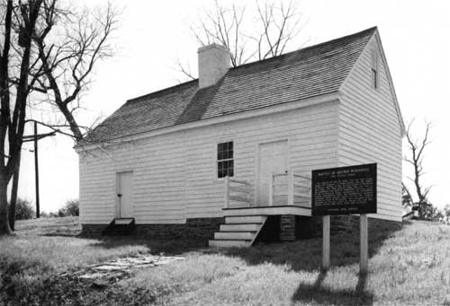
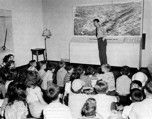
Instead of crowding floor space with exhibits, the Park Service used wall cases containing explanatory text, illustrations, and artifacts. This arrangement allowed visitors the opportunity to view panels of interest to them, gain important background information, and then explore the battlefields. The first room off the administration building lobby focused on the overall causes of the Civil War and key events during First Manassas, while the smaller second room contained the electric perspective map and room for a projector and lecturing space. Colorful panels compared the textbook tactics commanders had been trained to use and the troop movements during the First Battle of Manassas. Portraits of significant actors in the battles, including Robert E. Lee and Stonewall Jackson, and personal memorabilia of Generals James B. Ricketts and Fitz John Porter provided a human side to the history. Guns, swords, and uniforms gave evidence of the implements soldiers used in the battles. The electric map and the diorama, the latter much reduced in size from Hanson's and Wilshin's original plan, placed the exhibit artifacts in the larger setting of the northern Virginia terrain. [29] 1954 Boundary Legislation Interpretive activities at the museum could succeed only if the park itself remained a viable entity containing the most historically significant properties. As the Park Service sought protection for more lands through acquisition, it saw the need to define the extent of the battlefield park's boundaries. Initial discussions concerning Manassas boundary legislation proceeded from early attempts to purchase the Stone House. As Acting Director Tolson and Associate Director Demaray debated the legality of applying Interior Department funds to the Stone House acquisition, the larger concern of defining the ultimate park boundaries emerged. Demaray justified use of 1949 Interior funds for purchasing the Stone House, but he encouraged the idea of getting an act of Congress to identify further land acquisitions and fix the boundaries. Otherwise, an order of the secretary of the interior amending the original park legislation might be necessary for each addition of property. As a result, the Park Service turned to Congress for help in defining the Manassas National Battlefield Park's boundaries. [30] Limited success in acquiring the lands around the New York monuments added greater urgency to the idea of congressional action. The Park Service used the attention generated from the spread of residential and commercial developments near the monuments and the concurrent increase in property values to urge Interior and the Bureau of the Budget to approve a proposed bill defining the park's boundaries. Further prompting came from Al Gregory, a United Press correspondent noted to have considerable interest in the Civil War, who alerted President Harry S. Truman of the need for more land at Manassas. In response to these circumstances, Interior concurred with H.R. 3297, the second of eventually five bills that defined the Manassas National Battlefield Park's boundaries. [31] Key aspects of the Manassas boundary extension bills that elicited concern and resulted in revision or clarification included the amount of acreage to be added and the funding mechanism for purchasing the lands. House bills 5911, 3297, and 3041 allowed the addition of up to 2,500 acres while H.R. 5529, which became the final approved legislation, reduced this sum to 1,400 acres. H.R. 5911 and 3297 specified that the secretary of the interior acquire the lands by donation, purchase, or condemnation, but the final bill contained the changed phrasing to procure "in such manner" as considered in the public interest. Congress also sought assurances from the Department of the Interior that the bill would not necessitate a special appropriation of funds. Instead, the Park Service expected to acquire the lands through donations, land exchanges, or purchase using regular land acquisitions funds. The Bureau of the Budget signaled its concurrence with the boundary extension bill in February 1954. Approval of H.R. 5529 came on 17 April 1957. [32] Public Law 338 set the boundaries for the Manassas National Battlefield Park. While the southern boundary remained fixed along the Henry Hill property, Congress extended the southwestern boundary to include the New York monuments area. The act extended the western and northwestern boundaries from the New York monuments to the Sudley Church property, following State Highway 622. The Sudley Church property remained the northern limits of the park, but the law allowed for up to 250 additional acres adjacent to the north and west boundaries, so long as the total acreage added to the park under P.L. 338 did not exceed 1,400 acres. These proposed boundaries rounded out the park and provided a mechanism for connecting scattered tracts. [33] With the boundary legislation in hand, the Park Service continued its efforts to acquire the remaining lands around the New York monuments. Using 1954 and 1955 Department of the Interior funds, the Park Service spent $32,000 to purchase properties from Joseph Patterson and Willis Early. John Hottel had originally subdivided and sold these lots to Patterson and Early as housing tracts in 1947. In 1953 Hottel had sold a portion of his property, totaling twenty-three acres and including areas adjacent to each of the three New York monuments, for just under $12,000 to the Park Service. In November 1955 Hottel sold another five acres to the federal government, which centered on the 14th Brooklyn monument site, for $7,000. This five-acre tract commanded the significantly higher price due to its location in a commercially attractive area at the intersection of State Highway 622 and Lee Highway. [34] The New York monuments remained under state ownership well after the acquisition of the final critical tracts. In March 1953 Secretary of the Interior Douglas McKay expressed interest in having the state of New York transfer the New York monuments to the federal government, noting the Park Service's success in obtaining funding and making substantial progress in purchasing identified lots. But final action waited until May 1957 when the state deeded the three parcels of land containing the monuments. The Park Service accepted these monuments in June 1958. [35] |
|
| ||
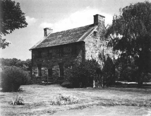
| <<< PREVIOUS | CONTENTS | NEXT >>> |
|
Battling for Manassas ©1998, Pennsylvania State University Press adhi/chap4.htm — 01-Apr-2001 | ||