|
Manassas National Battlefield Park Chapter 5: Reenacting the Past |

|
|
Chapter 5
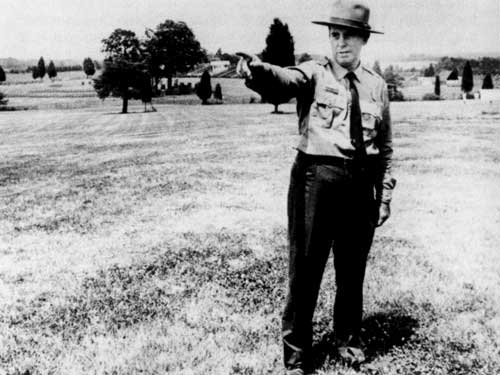
REENACTING THE PAST Francis Wilshin loved to tell the story of the First Battle of Manassas. During his tenure as superintendent of the Manassas National Battlefield Park, from 1955 to 1969, he had many opportunities, big and small, to enthrall listeners with his dramatic and accurate renditions. He could quote from soldiers' letters archived in the park's library and articulate complicated events so that visitors became converts to the cause of preservation. [1] Wilshin's devotion to the history of the Civil War stemmed from his familial connection to this event. One of his grandfathers had served in General J. E. B. Stuart's cavalry; the other had been a blockade runner. A native Virginian, Wilshin pursued his interest in Civil War and United States history, receiving a bachelor's degree from the College of William and Mary and a master's degree from Columbia University. He taught history briefly at Staunton Military Academy before joining the National Park Service in 1934 as a park historian at the Vicksburg National Military Park in Mississippi and then at the Saratoga National Historical Park in New York. Later, assigned to the Fredericksburg and Spotsylvania County Battlefields Memorial National Military Park in the 1940s, Wilshin delved into the history of First and Second Manassas and assisted Hanson with the Manassas National Battlefield Park museum displays. Through this experience, Wilshin developed an intense love in telling the story of First Manassas, to the benefit and detriment of the battlefield park. [2] Planning for Interpretation Wilshin's vision for educating visitors about the Manassas battles derived in part from ideas suggested by his predecessor, James Myers, who remained as superintendent until September 1955. Myers focused on expanded interpretive activities both in the administration-museum building and on the battlefields of First and Second Manassas. Having seen firsthand the phenomenal increase in park visitation following World War II—from 8,200 visitors in 1947 to more than 66,000 in 1951—without a concomitant increase in personnel, Myers devised additional ways to reach the public. [3] In the museum, Myers pushed for two additional electric maps with an accompanying taped talk to handle the increase in the number of school groups visiting the park. The number of students touring the park had increased from fewer than fifty in 1948 to two thousand in 1951. The existing electric map of the northern Virginia theater provided a good overall picture of then events leading to the two Manassas battles, but the map failed to show the tactical details of the battles themselves due to the map's spatial limitations. To tell the Manassas story, a trained park employee, usually the superintendent, had to manipulate the switches and narrate. An audio program linked to more maps would offer greater opportunities to educate school groups and other visitors without taxing the park's limited personnel. [4] Beyond the museum, Myers recognized that visitors needed more markers to explore the battlefield terrain on their own. The Henry Hill walking tour contained seven stops, while a separate six-stop driving tour directed visitors to the Stone House, the Sudley Church, the Stone Bridge, and the site of the Chinn House. Many spots on the driving tour did not include historical markings or had markers erected by state agencies. Recognizing the popularity of the Henry Hill tour, Myers recommended adding four stops to it and eventually integrating both the walking and driving tours into one comprehensive course. [5] Second Manassas remained almost entirely unmarked and undeveloped. The Dogan House had the only narrative marker devoted to the second battle, thanks to a $100 donation by a visitor. A few markers on the First Manassas driving tour provided references to the second battle, but for the most part interpretive efforts for the 1862 battle remained hampered by the fact that the federal government did not own key areas, such as the Deep Cut-Groveton monument area. [6] Until funding became available to acquire lands associated with the Second Battle of Manassas, Myers focused on developing text for a series of historical markers that would be put in place after acquisition of the lands. With guidance from the regional and Washington offices of the Park Service and assistance from NPS historian Frank B. Sarles, Myers identified nine locations for the proposed self-guided auto tour and composed the historical narratives for the markers. Areas specific to Second Manassas included Buck Hill, Groveton, and sites along the unfinished railroad. [7] Myers's efforts to expand interpretive activities in the museum and on the self-guided tours could go only so far in accommodating the staggering increases in visitation. Assistance from a permanent historical aide, who joined the park staff in 1948, and a seasonal ranger-historian, who helped for at least two summers in the early 1950s, gave Myers more flexibility than the two previous superintendents. But on Saturdays, Myers remained the sole park employee on duty. [8] Myers's efforts served as an immediate stopgap to the demands of surging visitation. All national park sites had become overburdened with eager tourists, and long-term planning, including interpretation and preservation, received insufficient focus. To address this worsening situation, the National Park Service adopted the Mission 66 program. This ten-year parks improvement program, slated to end on the Park Service's fiftieth anniversary in 1966, provided funding and direction for each park. At Manassas, Myers's interpretive planning became a foundation for the park's Mission 66 prospectus, which was implemented by Wilshin as the new superintendent. Mission 66 Planning Wilshin identified land acquisition and interpretation as the two focal points for Manassas National Battlefield Park under the Mission 66 program. The federal government owned scattered tracts mainly associated with First Manassas. By acquiring the intervening lands, the Park Service hoped to create a cohesive park with readily apparent boundaries. This approach would buffer the parklands from future outside developments. The Park Service also recognized that key tracts related to Second Manassas were needed to tell the story of this battle. Wilshin knew that a successful interpretive program relied on incorporating these lands. First, visitors could explore more areas and obtain a fuller understanding of the significant activities associated with each battle. Second, the Park Service planned to build an internal road system linking the different sections. Visitors would then have leisurely and safe access to the chief points of historical interest without having to fight outside traffic traveling through the park. Third, the Park Service would incorporate the new lands into an improved system of trail-side markers and exhibits, as Myers had suggested. [9] Land acquisition plans under Mission 66 focused on those tracts designated for inclusion in the 1954 boundary expansion legislation. Much of the property north of Lee Highway remained privately owned and had priority attention during Mission 66. Wilshin also pushed for two properties not identified in the 1954 legislation, namely, Battery Heights, a key artillery position of the battle of Second Manassas, and the Stone Bridge, a significant landmark in both battles. According to the 1954 legislation, the Park Service could pursue acquisition of these lands so long as the total amount did not add more than 1,400 acres to the existing park. [10] With the addition of these areas, Wilshin could focus his attention on interpretive improvements in both the museum and around the park. For the museum-administration building, now called the visitor center, Wilshin proposed adding a wing for group presentations and orientation purposes. He also saw the need for expanding the parking lot to accommodate increased numbers of visitors and for installing the two electric maps that Myers had previously suggested. To provide greater museum exhibit space, he suggested finishing the second floor of the visitor center. Park Service officials could not justify the second-floor exhibit space, but they did approve construction of the wing and again considered building the electric maps. [11] Within the park, Wilshin recommended a system of hard-surfaced roads with adequate parking areas to make the different historic areas of the park more accessible. Directional markers would lead visitors to these sites, and permanent narrative markers would describe the significance of each point. To augment the number of visitor contact places, Wilshin proposed rehabilitating and opening the Stone House for exhibit as a field hospital. He also suggested stabilizing the Dogan House and stationing interpretive personnel there. Ronald Lee, chief of the NPS Division of Interpretation, agreed with most of Wilshin's proposals, except staffing the Dogan House. Its proximity to the visitor center and the Stone House precluded adding another contact station there. [12] Mindful of the value of providing the public with tangible indications of troop positions for both battles, Wilshin proposed mounting cannon and markers. He suggested that the park's library collection be bolstered to assist in the extensive research needed to establish the exact positions of key batteries. Wilshin initiated a search for cannon and quickly achieved success, obtaining seven cannon from the Chickamauga-Chattanooga and Petersburg National Military Parks in 1956. The Eastern National Park and Monument Association also provided period guns and two carriages, which were used to mark the location of James Ricketts's and Charles Griffin's Federal batteries during First Manassas. [13] Wilshin's suggestions for Mission 66 at the Manassas battlefield park did not depart significantly from proposals offered by previous park superintendents. Myers wanted to augment the tour marker system, especially for Second Manassas. Hanson had conducted initial research on troop positions and had tried to replace temporary markers with permanent ones. Hanson had also proposed constructing a separate assembly space in the museum-administration building in his initial 1939 museum plans. In the 1930s the National Park Service had intended to build a system of roads and contact stations to assist viewers in touring the proposed 10,000-acre Bull Run Recreational Demonstration Area. Wilshin had the good fortune to serve as superintendent when enhanced funding levels made these dreams a possibility, and he incorporated them into his Mission 66 planning. [14] Wilshin laid out an ambitious program for the battlefield park that relied on adequate funding and proper management to succeed. His anticipated land acquisition program alone would have required several hundred thousand dollars. When he pursued this funding in conferences with the regional office, he quickly learned that land money remained limited and that Manassas would have to compete with a host of other park areas for what was available. Funding levels also influenced how many narrative markers, museum displays, roads, and other interpretive aids could be built. [15] To achieve all these Mission 66 plans, the park needed leadership capable of finding the necessary resources and guiding each of the projects to completion. Wilshin eventually overcame the funding limitations for land acquisition, and he oversaw an expansion of the visitor center with a new auditorium wing. Despite these successes, Wilshin failed to complete other significant Mission 66 projects for the park, most notably the renovation of the museum displays. His devotion to certain aspects of the Manassas battlefield story and his commitment to acting both as superintendent and historian at the park determined which Mission 66 projects had his full attention. Threatening the "Very Heart" of the Park Before Wilshin had the opportunity to delve into any of the Mission 66 projects, he had to contend with the Virginia state highway department, which proposed to route a new interstate along Lee Highway through the middle of the park. Wilshin recognized immediately the terrific impact the proposed interstate would have on the battlefield park. He first heard of the state's intentions in spring 1957 when the Virginia Department of Highways announced that a new interstate highway would run east-west from Washington, D.C., to the Shenandoah Valley, following Lee Highway in Prince William County. Needing further information to evaluate the road's impact on the park, Wilshin requested, and obtained, from the state highway officials a map superimposing their plans on the layout of the battlefield park. In early March, state officials presented their proposal to a packed house in the park's museum building. [16] At the 12 March meeting, Wilshin, Region 1 Director Elbert Cox, and retired superintendent Hanson learned that the new interstate would require widening Lee Highway to at least three hundred feet for the combination of the east-west lanes, median strip, side strips, and service roads. Engineers also expected to place an interchange at Route 234, where the Stone House stood. The resulting cloverleaf would necessitate the development of additional land at that intersection. [17] Listening to the state's plans, Wilshin and the other National Park Service attendees knew that the interstate would do "irreparable damage to the very heart" of the battlefield park. The widened road would make a "major intrusion" on Henry Hill and destroy some of the historic areas near the Stone Bridge. The Stone House frontage and the high ground where the New York monument honoring the 14th Brooklyn Regiment stood would be jeopardized. And how could the Park Service preserve the overall battlefield appearance and complete its plans under Mission 66 with this modern intrusion? Wilshin, Cox, and Hanson expressed these misgivings at the 12 March hearing, and later Cox and Director Wirth filed formal statements asking the state to reconsider its plans. [18] Wilshin knew that the Park Service's arguments alone would not sway the highway department. Despite the concerns raised by the NPS, state officials held firm to their proposal, "like a horse with a bit in his teeth," noting the plan's economic advantages. Fearing the worst, Wilshin resolved to act aggressively. With permission from interpretive chief Lee, Wilshin addressed the Civil War Round Table of Washington, D.C., which coincidentally met the evening of the state highway hearing. Round Tables represented local clubs of Civil War enthusiasts. Acclaimed Civil War historian Bruce Catton was the scheduled speaker, and three hundred members were in attendance. In a booming voice that echoed over the microphone system, Wilshin painted a somber picture of Manassas National Battlefield Park once the interstate had "carve[d] it up." Henry Hill would be "mutilated beyond recognition," and the monument land that the state of New York had recently donated to the National Park Service would be "completely despoil[ed]." He urged his fellow members to take a stand, like the Greeks at Thermopylae, against this threat. [19] The response was immediate and effective. That night the D.C. Round Table adopted a resolution that protested the proposed "desecration" of Manassas National Battlefield Park and petitioned the state highway department to select an alternative route for the interstate. The D.C. Round Table sent its resolution to some eighty other Round Tables, with a total membership of about ten thousand, and various other patriotic organizations, alerting them to the danger. Round Table members and others flooded Congress and the Virginia state highway office with letters objecting to the proposed route. In a typical response, the Robert E. Lee Camp No. 726 of the Sons of Confederate Veterans of Alexandria, Virginia, lodged a complaint against any highway that would interfere with or destroy the monuments and memorials erected on the hallowed ground at Manassas. [20] Building on this support, Wilshin adopted a publicity strategy that became his standard tactic for future battles to protect the park. He appeared before a host of civic and patriotic organizations, including the Manassas Chapter of the United Daughters of the Confederacy, the Warrenton Rotary Club, and the Manassas Historical Association. Even before the 12 March state highway meeting, he had spoken to the Manassas Chamber of Commerce, the Lions Club, and the Kiwanis Club. He obtained support from the mayor, members of the Manassas town council, and the Prince William Board of County Supervisors. Newspapers in Manassas, Washington, and Richmond printed articles and editorials informing readers of the situation. Local radio and television stations aired stories. The plight of the Manassas battlefield park gained national attention when Chet Huntley and David Brinkley presented the story on the 24 March airing of Outlook. [21] Wilshin enlisted help from everyone he met, and fortuitously he gained a lifelong ally in Anne (Annie) Delp Snyder. Snyder and her husband Waldon Peter (Pete) had bought a 180-acre cattle farm next to Manassas battlefield park following World War II. Originally from Pittsburgh, she had thought of the Civil War only as a "name in the history book" until she had a personal tour of the Manassas battlefield with Wilshin. As she later recalled, Wilshin made you feel as if you were there, seeing the soldiers and hearing their thoughts as they engaged in battle. Nothing was left to the imagination in his presentation, and Snyder walked away so awed and overwhelmed that she became an instant convert to the importance of the battlefield park. [22] Snyder's conversion coincided with the interstate highway controversy, and Wilshin recruited her for his letter-writing campaign. It was the first campaign of many that she would embrace in connection with the Manassas battlefields. Snyder was accustomed to challenges. During World War II she had dropped out of law school and joined the first class of women to graduate from the Marine Officers Candidate School to "free a Marine to fight." She worked as a recruiter in New Orleans, convincing men that having their daughters, sisters, and wives in the Marines was not "selling [them] into prostitution." She gained sophisticated public relations skills that she honed in her future Manassas battles. She credits Wilshin with sparking her preservationist sympathies and teaching her many of the methods for accomplishing her goals. [23] Wilshin's strategy in the interstate highway crisis proved pivotal. Inundated with letters from Civil War Round Tables as far away as England, the state highway commission quickly agreed to consider alternative routes. With continued pressure from Wilshin and his supporters, the state eventually adopted a southern route. This decision proved a happy solution to the issue because it saved the park from destruction and provided room for future highway expansion without harming the park. [24] Surprisingly, the chairman of the Prince William Board of County Supervisors resurrected the idea of using Lee Highway for the interstate in early 1958. As Wilshin later recalled, the chairman wanted to protect two farms held by his friend William Wheeler, which would be affected by the southern routing of the interstate. In response, Director Wirth, Wilshin, and other NPS representatives together with Virginia state highway and Prince William County officials presented their case to Rep. Howard Smith, who had expressed support for widening Lee Highway. Smith had long been interested in the battlefield park, having assisted the Park Service in acquiring lands during the Bull Run Recreational Demonstration Area period and drafting the first boundary expansion bill in 1949. Wirth argued strenuously against the highway change, saying that he could "never live with it" or the idea of letting down the Round Tables and other groups who had come to the park's defense. Using troop position maps to show that the proposed area included the sites of some of the heaviest fighting in both Manassas battles, the Park Service convinced Smith to stay with the southern route. [25] More Lands for the Park With the battle over the routing of the interstate highway won, Wilshin still had to contend with the larger issue of land. A housing boom hit the town of Manassas in 1958, and land values steadily increased by 15 to 20 percent each year during the remainder of Wilshin's superintendency. The prospect of direct access to Washington made the area near the battlefield attractive to developers. Wilshin knew that lands designated for inclusion in the park might become prohibitively expensive if the Park Service did not act quickly. Tracts might end up part of housing developments or shopping centers, their historic landscapes buried under concrete and asphalt. [26] Wilshin understood the value of these lands to the battlefield park, and he shared this knowledge with anyone who would listen. His modus operand was to depict on maps troop movements during each Manassas battle, explaining that the Park Service established the relative significance of given tracts based on the official records of the war. Land acquisition plans developed from this information. Finally, as the park's interpretive program took shape, Wilshin incorporated information on battle movements and historic lands in museum displays and historical markers. In this way, Wilshin showed that the park's land acquisition program followed a thoughtful approach based on the history of the battles and alleviated fears that the Park Service wanted the lands for other purposes, such as park housing. [27] Wilshin used every means available to him to acquire historic lands. He learned in 1957 that the owners of the Stone House Inn planned to sell their property at public auction. The inn's land adjoined the Stone House tract, which the park had purchased in 1949, and consisted of a restaurant, warehouse, and three cottages. By virtue of its proximity to the site of heavy fighting during the Civil War, the Stone House Inn was an important tract long considered for inclusion in the battlefield park. Wilshin prodded the regional and Washington offices to find the necessary $35,000 to buy the inn. National Park Service interpretive chief Ronald Lee scraped up the money, and the Stone House Inn transferred to the federal government in 1958. [28] The experience of purchasing the Stone House Inn with miscellaneous NPS funds indicated to Wilshin that he needed a large, secure financial base to accomplish his Mission 66 land acquisition objectives. The interstate highway controversy taught him the importance of gaining allies and publicizing his efforts. He applied these lessons to the park's land program. Wilshin often gave personal tours of the battlefield, especially for congressional and other political representatives. By making contacts, Wilshin hoped to attain his goals for the park. His efforts were richly rewarded in 1958. [29] Sen. John Stennis (D-Miss.) arrived unannounced at Manassas National Battlefield Park one day in April 1958 and accepted Wilshin's offer of a guided tour of the battlefield. Wilshin took Senator Stennis to the Stonewall Jackson statue. While looking north across Lee Highway, Stennis asked what lands the federal government actually owned. Wilshin replied that the park included "a solid block of land" south of the highway running from the Stone Bridge almost a mile and a quarter to Groveton. But, pointing to Matthews Hill behind the Stone House where Mississippi troops had fought with Confederates Barnard E. Bee, Nathan G. Evans, and Francis S. Bartow the morning of 21 July 1861, Wilshin stated, "Sir, we don't own that land." Stennis struck his fist into his hand and exclaimed, "That's not right!" Wilshin then escorted Stennis to the high ground west of Deep Cut. He related the story of how Confederate Stephen D. Lee's artillery permitted Robert E. Lee's army to sweep the field, thus turning the tide of Second Manassas. With perfect timing, Wilshin ended with the reprise, "Sir, we don't own that land." And, Stennis returned, "That's not right!" Back in Wilshin's office, Stennis asked what lands had the highest priority, and Wilshin responded with two key areas of Second Manassas, Battery Heights and Deep Cut. Stennis wrote them down, and by the end of August he had coaxed the Senate to pass a Supplementary Appropriation Bill providing $100,000 for land acquisition at Manassas. [30] Stennis remained committed to getting more lands at Manassas, partly because some of his relatives had fought there. He and Wilshin kept up a correspondence, and the senator provided the park with some letters from his family collection relating to the battles. In 1959 Stennis returned to the funding issue and convinced Congress to appropriate $450,000 toward land acquisition at Gettysburg and Manassas. [31]
The Manassas battlefield park eventually obtained the entire sum because Congress had stipulated that the money could not be obligated until the secretary of the interior confirmed that local governments had adopted adequate zoning regulations to assure against future commercial developments in the park areas. Gettysburg did not have any zoning laws, but the Prince William Board of County Supervisors had already zoned the area surrounding Manassas battlefield park as agricultural-forestry, which was in line with the congressional requirement. The board of supervisors disapproved the proposal supporting further land acquisition for the park, but the Manassas town council had passed a resolution in April 1959 expressing its support for further land acquisition. With the proper zoning in place, the total obligation of $450,000 went to Manassas. [32] With $550,000 available, the Park Service embarked on an extensive land purchase program at Manassas. Most of the land acquired lay north of Lee Highway, the area Wilshin had pointed out to Senator Stennis. The Stone House and the Dogan House, which had been the lone park properties on the north side of the highway, now had the protective embrace of national parkland around them. Tracts immediately along Bull Run remained privately owned, but most of the land along Route 234 to Sudley Church came into the park. [33] Wilshin explored the possibility of using land exchanges to acquire other significant tracts, including the Stone Bridge. The Stone Bridge had served as the left anchor of the Confederate line at First Manassas and had been an avenue of Union advance and the principal avenue of Union retreat during Second Manassas. The Commonwealth of Virginia held title to the bridge and about three acres of land around it. The Park Service offered to exchange its temporary leases on roadway relocations near Sudley Church and the south boundary of the park for the Stone Bridge and its land. Virginia agreed to the proposal, but with a stipulation. The federal government had to obtain an agreement from the United Daughters of the Confederacy to transfer to the Park Service a monument the organization had erected on the bridge. [34] Wilshin faced a delicate situation when he approached Isabel Hutchison, the president of the UDC chapter in Manassas, about the Confederate monument on the Stone Bridge. He wanted the bridge, but the monument represented an intrusion on the historic scene. So he had to convince Miss Hutchison, a devoted Confederate, to agree to the transfer and demolition of her organization's memorial. He had already established friendly relations with her chapter by assisting in First Manassas anniversary ceremonies, so he built on that relationship. He showed her Civil War-era photographs of the bridge to indicate its original appearance and explained its significance to the battles. He then argued that transfer of the bridge and removal of the monument would "further the cause of her dear Confederacy" by restoring the historic appearance of the Stone Bridge. Miss Hutchison and her chapter agreed to Wilshin's proposal, and the Stone Bridge came into the park in 1961. [35] The Park Service sometimes acquired lands under less friendly circumstances. The federal government, anxious to consolidate its holdings in Manassas now that it had the money and the impetus provided by Mission 66, resorted to a process known as a declaration of taking to condemn property that landowners refused to sell. Government officials also used this procedure if a property owner threatened the historic features of property that had been designated for inclusion in a park. In response to a refusal to sell land associated with Battery Heights, the Park Service chose to use a declaration of taking against the Steele family, who owned one tract of this historic scene, and Luther Tinsley and Virginia Huffman, who owned one of the other tracts. [36] As one longtime neighbor of the park remembers, Arthur and Rosalie Steele had built a nice house on their property in anticipation of retiring there. They had no children, and they intended to will their tract to the Park Service, but they wanted to spend their last years on their land. The Park Service did not want to accept this condition and proceeded with a declaration of taking. The United States District Court ruled on the price for the settlement, based on an assessment of the land, and the Park Service accepted the land in October 1960. The rest of Battery Heights transferred to the Manassas National Battlefield Park in 1962. [37] Land condemnation antagonized relations between the battlefield park and its neighbors. People like the Steeles, who had either grown up on these lands or spent most of their adult lives there, wanted to decide for themselves when to leave, not be removed forcibly by the government. In the case of the Steele property, the Park Service exacerbated the situation by turning the Steeles' retirement home into park housing. Further conflicts occurred because land acquisition plans remained confidential to avoid driving up prices. But landowners never knew for sure if their property, which may have been within the designated park boundaries, was on the list for immediate acquisition. This situation increased tension and drove rumors of massive land buying by the government. [38] Wilshin tried to alleviate residents' fears. He met with them and explained why certain tracts merited inclusion in the park, and he stressed that the Park Service intended to limit its purchases to ground essential to park interpretation. These efforts settled some of the wilder rumors, but the park continued to have opponents within the local community because of its land acquisition dealings, lasting for decades. [39] Planning the Reenactment In late 1958 Wilshin and fellow Civil War enthusiasts in the local community conceived the idea of staging a reenactment to mark the one hundredth anniversary of the First Battle of Manassas. This reenactment was only one of many programs around the country sponsored by the national Civil War Centennial Commission and various state organizations to commemorate the events of 1861-65. President Dwight D. Eisenhower and Congress en couraged these tributes, but local communities and private organizations did most of the work for the centennial. Companies like Sinclair Oil Company tied their product promotions to specific commemorations and helped inform Americans about the centennial. [40] National interest helped keep Wilshin and other supporters committed to the idea of a reenactment. In early 1960 they established a nonprofit agency dedicated to producing the reenactment. First Manassas Corporation, Incorporated, gained early support when the governor of Virginia, the Virginia Civil War Centennial Commission, and the counties of Prince William and Fairfax contributed $50,000. Adding further impetus to their plans, organizers hired Maj. Gen James C. Fry (Ret.) to serve in a full-time capacity as executive director of the corporation. [41] Planning for the reenactment accelerated once the First Manassas Corporation became a reality. Wilshin completed an advance plan for the event in February 1960, in which he proposed staging the intense artillery fight on Henry Hill during which Jackson acquired his nom de guerre. Wilshin provided cost estimates and ideas on where to find the needed cannons and individuals for the event. Two months later, the First Manassas Corporation released a more formal prospectus to generate interest in the reenactment and, it was hoped, drum up further financial support. By the end of summer, the corporation had obligated considerable sums of money and had arranged for national and international advertising. [42] National Park Service involvement in the reenactment developed gradually. Wilshin remained active in the First Manassas Corporation as a director, and his participation gave the appearance, at least, of Park Service support for the corporation's activities. As the First Manassas Corporation made further commitments toward staging the reenactment, Park Service personnel slowly realized that the battlefield park and its caretaker, the federal government, had unofficially blessed the event. This relationship was formally acknowledged in May 1961 when the National Park Service entered into a cooperative agreement with the corporation. [43] Under the agreement's terms, the First Manassas Corporation would provide the facilities and services necessary to produce and present the historical pageant" of First Manassas. These conveniences included adequate seating and sanitary facilities for the expected crowds. The agreement required that parking and shuttlebus services be provided to accommodate the expected crowds. The Park Service also stipulated that the corporation make refreshments available to visitors. In return, the National Park Service agreed to provide the land for the event at no cost, with the condition that the historical character of the park be preserved. Park Service personnel would also provide technical advice. [44] Long before the cooperative agreement was signed, Wilshin helped cement the Park Service's commitment to the reenactment. As superintendent, he made the reenactment an integral component of the park's Mission 66 program despite the fact that he had not included the reenactment in his original development planning for the park. In many ways, this decision complemented the Mission 66 goals he had set for the park. The 22 July 1961 date was a closer and more historically relevant deadline than the fiftieth National Park Service anniversary in 1966. Wilshin accelerated land acquisition and other Mission 66 projects so that they might be done in time for the reenactment. Some Mission 66 plans, such as historic structure improvements, gained heightened attention. The Dogan House and the Stone House were valuable stage props, with the Dogan House serving as a small rural home caught in the crossfire and the Stone House representing a building forced into use as a field hospital. Exterior restoration of the Dogan House, completed between June and November 1960, involved straightening and leveling the building, replacing rotted timbers, and rebuilding the stone foundation walls. Interior work, completed in May 1961, included replacing plaster, trim, and floorboards. Planned Stone House restoration work involved repair of the foundation and masonry walls and replacement of the roof. [45] While land acquisition and historic structure renovations proceeded on schedule, delays plagued other aspects of the park's Mission 66 program. The planned revisions to the museum displays in the visitor center and the field hospital exhibit in the Stone House were not completed until well after 1961, despite their relevance to the reenactment. The Stone House exhibit as outlined in the Mission 66 plan would explain the conditions soldiers faced when injured. The museum displays would be upgraded to provide more background information about the battles. Wilshin was interested in these interpretive displays, as evidenced by his extensive research on the Stone House and his involvement with Park Service exhibit planning teams. However, he came to rely on the reenactment for fulfilling significant interpretive plans. [46] Instead of completing museum displays, Wilshin hoped to enhance the park's interpretive program through reenactment activities. Spectators would gain greater understanding of battlefield conditions by witnessing a historically accurate staging. Filming the event would allow later visitors to share this experience. Wilshin intended to show the resulting movie regularly in the park's visitor center. Another interpretive aid that Wilshin hoped would materialize was construction of an impressive facility to house a Civil War hall of fame at the battlefield park. As proposed by the First Manassas Corporation, this large marble building would house a library, flag hall, large rotunda, and administrative functions. Park Service Director Wirth lent his support to the hall of fame idea; however, because of funding and organizational problems associated with the reenactment, neither the film nor the hall of fame advanced beyond the planning stages. [47] Producing the reenactment proved more difficult than Wilshin and the First Manassas Corporation had anticipated. The enterprise encountered serious financial difficulties. Individual donations and sponsorships by interested organizations augmented the $50,000 provided by the state of Virginia and local counties, and a professional fund raiser was hired to help secure financing. But these efforts did not produce the $200,000 estimated for the event, and the First Manassas Corporation came to rely on expected revenues from the actual event to cover its costs. [48] Organizational problems compounded the financial worries. Major General Fry continued to direct the operation, but the expected full-time twelve-member staff never materialized. Instead, planning devolved to committees, which worked on a part-time, voluntary basis. Committee members often failed to coordinate their activities. The lack of overall leadership left the National Park Service committing personnel to the daily planning of the reenactment, a task the Service had assigned to the First Manassas Corporation in its cooperative agreement. Wilshin devoted his energies to the production, and in May 1961, the regional director added J. Leonard Volz as the National Park Service coordinator to assist in the final planning and preparations. [49] The National Park Service had expected the First Manassas Corporation to address certain details early in the planning, but many crucial tasks remained incomplete as the date of the event neared. As late as 19 June, Volz warned the regional director that the corporation had not addressed the "extremely important matter" of sanitation facilities. Press relations, which waited until "late in the game," suffered from Major General Fry's "dictatorial manner." The Park Service's regional publications officer had to step in ten days before the reenactment and run interference by providing adequate parking, phone access, and press boxes because Major General Fry had refused to make special accommodations for the press, except for Life Magazine and National Geographic, which had made prior arrangements. [50] Some Park Service personnel believed that the administrative difficulties resulted in part from Wilshin's participation in the planning of the reenactment. Wilshin had a personal passion for the First Battle of Manassas, drawn from his southern background and interest in the Confederate cause. His enthusiasm for staging a historically correct and awe-inspiring recreation overrode more practical considerations. For instance, he pursued the idea of lining both sides of Lee Highway, from Fairfax to the Manassas battlefields, with the flags of the Union at the time of the Civil War. When asked who would pay for the flags and protect them, Wilshin dismissed the query. He talked of crowds numbering 200,000, but he could not imagine the logistical details needed to accommodate so many people. He even remarked at one point that two latrines on Chinn Ridge would be sufficient. [51] Reenactment organizers chose to depend on Wilshin's historical understanding of First Manassas and not on his weaker administrative skills. As technical adviser, Wilshin prepared the script for the reenactment and provided information on the placement of troops and cannons. Volz highly recommended Wilshin to serve as narrator during the actual production because he could accurately and dramatically cover any delays in timing. At times, Wilshin's command of the history put him at odds with the management of the event. He insisted that all reenactors wear authentic uniforms, down to the style of buttons. In 1961 reenactors had not developed the sophistication in attire and weapons that they displayed in later decades. Requiring authenticity would have added large expenses to the already strapped finances. Instead, Fry and others convinced Wilshin to use inexpensive substitutes, like standard gray pants and jackets from Sears Roebuck and Company. [52] First Manassas Reenactment Administrative problems and financial worries melted away under the blazing sun and 90-degree temperatures when Manassas National Battlefield Park hosted the reenactment of the First Battle during the 21 July weekend. On Friday the First Manassas Corporation staged an open dress rehearsal before an audience of 20,000 visitors and the press. Stories in the morning papers attracted another 55,000 people on Saturday and 45,000 on Sunday. A number arrived in period costumes, reminiscent of the audience that had traveled from as far as Centreville on that July day in 1861 to witness the first "skirmish" of the war. [53]
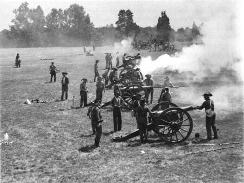
For Wilshin, the reenactment was a very exciting thing. He long remembered the feeling of being right in the battle, with bombs going off and dirt flying around the charging men. The sight of the battle flags and the sounds of the men yelling gave a real sense of the actual battle experience. Timing of the attacks and counterattacks sometimes varied from the script, but the general effect was so close to the original that viewers experienced the fear, the excitement, the carnage of First Manassas. [54] The zeal of the reenactors added to the drama. Many belonged to the North-South Skirmish Association, a national organization that represented units of both the North and South and was dedicated to the preservation of the history and spirit of the Civil War. As the skirmishers assembled in mass formations, attacked over open ground, and fired point blank at each other, the audience gained a real sense of battle conditions. The sound of cannons and the crack of a Civil War musket provided a rare opportunity for everyone to touch the past. As Wilshin fondly recalled, some reenactors were so interested in being part of the action that they were unwilling to play dead but got up and reentered the fray. [55] Spectators and some of the press responded warmly to the show. One viewer noted that the reenactment allowed a greater visualization of history than "cold stone monuments or words on paper" do. The audience was caught up in the reenactment toward the end of the production. At the point late in the battle when Confederate forces pushed Union forces off Henry Hill and into retreat, "sustained rebel yells" erupted from the mostly southern audience. Newspapers took this spontaneous show of support for the South as indicative of a larger involvement in the nation's past. Accounts emphasized the sense of national unity that the reenactment drove home. People had the chance to see the sacrifices Americans had made to defend deeply held beliefs, both for the North and the South. [56] This enthusiasm from participants and spectators for the reenactment made assessing the value of the event difficult. In his opening remarks for the 22 July presentation, Director Wirth welcomed the reenactment as a way to "visit the inspiring scenes of the past" and gain "strength, imagination, and wisdom" to prepare for the future. Wirth recognized the educational benefits the reenactment and proposed film provided the public, but he also saw the effort, expense, and hazards inherent in the production. The National Park Service had paid a heavy cost in terms of personnel time to supervise the event and in direct outlays, such as $10,000 for sanitary facilities. The potential for serious injuries or damage to the battlefield remained a concern. Some resource damage to the historic lands included Chinn Ridge, where heavy usage by camping reenactors necessitated reseeding. Well-defined wagon wheel tracks from the show cut into other parts of the battlefield and required attention. [57] Another significant concern involved the overall appearance of the reenactment and how this event influenced opinions about the Park Service. While the spectators and some of the press gave favorable reviews, other newspaper reporters slammed the reenactment as a "farce" which allowed "overgrown boys" to get a "thrill" from hearing guns go off. An editorial cartoons in the Washington Star showed the endless traffic, with cars banged up against each other and people fuming in the heat, instead of the more historically significant aspects of the event. Even Park Service personnel admitted to the commercialism of the production, especially the "Coney Island" atmosphere behind the spectator stands. After coordinating the final aspects of the reenactment, Volz concluded that the show appeared to be more a celebration than a commemoration of a tragic historical event, a result that the organizers of the overall Civil War Centennial had feared, leading them to advise against planning reenactments. Volz and others realized that although the National Park Service was not blamed for the less dignified aspects of the Manassas reenactment, the agency might not receive the same treatment in the future. [58] Based on these concerns, Director Wirth established a National Park Service policy not to authorize any future reenactments on parklands. A previous commitment to hold a reenactment at Antietam in September 1962 would be honored, but further productions would not be sanctioned by the Park Service. Wirth encouraged demonstrations of musket firing and troop drills, flag presentations, and parades in period costumes as suitable replacements for reenactments. The Park Service saw the value of "some sort of pageantry" to help visitors visualize the past through a "dignified and impressive commemoration." At Manassas National Battlefield Park, newly enlarged and enhanced through Mission 66 improvements, these quieter commemorations marked subsequent anniversaries of the two historic battles. [59] |
|
| ||
| <<< PREVIOUS | CONTENTS | NEXT >>> |
|
Battling for Manassas ©1998, Pennsylvania State University Press adhi/chap5.htm — 01-Apr-2001 | ||