|
Manassas National Battlefield Park Chapter 3: Settling In |

|
|
Chapter 3
SETTLING IN Set in Virginia's piedmont upland region, the Manassas battlefields in 1940 were adequate but not exceedingly productive farmland consisting of gently rolling hills cut by relatively steep stream valleys. Second growth forests punctuated the more numerous open fields. Tributaries of Bull Run, a stream that served as the eastern boundary for the park, watered the area and fed into the larger river systems of the Occoquan and Potomac. The moderately rich soil contained an underlayer of shale, which occasionally surfaced as outcroppings. [1] Underneath the physical features, this landscape resonates with the touch and sound of the past. Nomadic Manahoacs hunted buffalo that once grazed on the grass-covered plains the Indians created by regular burning of the forests. By the mid-seventeenth century, English colonial settlers moved out from the Tidewater region, displaced the Indian population, and established small farms. In 1724 Robert "King" Carter claimed several portions along Bull Run for various family members and formed a network of large plantations worked by slaves. In the first half of the nineteenth century, the Warrenton Turnpike and later the Orange & Alexandria Railroad hastened settlement in the area and travel farther west. An important strategic position, the railroad line and its junction at Manassas drew the Federals and Confederates in July 1861 to their first major land confrontation. [2] References to the landscape in soldier accounts from First Manassas link past and present and heighten the importance of preserving the countryside for posterity. An optimistic William Thompson Lusk, fighting for the Union army, wrote in a letter home, "we rushed by the flank, over fields, through woods, down into ravines, plunging into streams, up again onto rising meadows, eager, excited, thrilled with hot desire to bear our share in routing the enemy." For Lusk, the continually changing environment reflected his boundless energy in defeating the Southern cause. Confederate soldier Charles Minor Blackford described his view of Henry Hill in quiet terms, suggesting a more ambivalent mood. Blackford wrote to his wife Susan: "we were thrown into line about sunrise on the brow of a hill which overlooked Bull Run, with quite a wide valley (two hundred yards at least), below us. On the other side the bluff rose quite steeply, but on top of it there was an open field." Not elaborated, snippets of description provide clues to the lay of the land and its importance in the experiences of the men fighting. The National Park Service, in turn, strove to capture for its visitors these and other Civil War experiences that the land held. [3] Stonewall Jackson Statue and the Administration-Museum Building The National Park Service retained the basic administrative structure established under the New Deal's recreational demonstration area program when Manassas became a unit of the national park system in 1940. Branch Spalding continued to serve as coordinating superintendent from the Fredericksburg and Spotsylvania County Battlefields Memorial National Military Park, where he remained closely involved in making park decisions. Regional direction came from Region 1 headquarters in Richmond. For managing routine activities at Manassas, the Park Service appointed Raleigh C. Taylor as the first superintendent. Taylor supervised relief workers employed by the Bull Run project, who remained until June 1941 to complete various special improvements. [4] In spite of a tenure shortened by his taking military furlough in early spring 1942, Taylor saw the long-awaited transformation of the battlefields from privately owned lands to a national park site with the appropriate visitor services. This change in ownership led to the development of the historically rich Henry Hill area, with the Park Service focused on educating Americans about the battlefields. Two early and significant projects proceeded with the nudging, or outright contributions, of outside organizations. First, in 1938 the state of Virginia appropriated $25,000 for the erection of an equestrian statue commemorating Stonewall Jackson's unassailable line on Henry Hill. Second, as a result of negotiations with the Sons of Confederate Veterans for the Henry Hill tract, the Park Service promised to build a museum at Manassas. These two landmarks, located on Henry Hill, focused attention on the First Battle of Manassas and proclaimed the existence of the national park. [5] Initial thoughts for a Jackson statue emerged from the seventy-fifth anniversary reenactment of the first battle, held 21 July 1936. Sponsored by the National Park Service, a local community organization, and the Manassas-Prince William County Chamber of Commerce, the event brought 2,000 Army and Marine Corps troops onto the field that had witnessed the climax of operations in 1861. During these festivities, Coordinating Superintendent Spalding suggested erecting a "suitable monument" for Jackson to replace the poorly lettered sign that marked the historic site. No action was taken until 1938 when the Virginia legislature appropriated funds and the Sons of Confederate Veterans included a provision for its construction in its deed of conveyance with the federal government. [6] Virginia state agencies selected the sculptor and design, and the Park Service advised on the placement of the statue. Originally, the Virginia Museum of Fine Arts, acting for the Virginia Conservation Commission, intended to cooperate with the National Fine Arts Commission in artistic review of the submissions, but controversy resulted concerning the ultimate jurisdiction and final authority of the two agencies. The state agency held its ground and chose Italian-born Joseph Pollia. Trained at the school associated with the Boston Museum of Fine Arts, Pollia had sculpted several monuments to American history, including a Spanish-American memorial on San Juan Hill in Cuba and a statue of Union General Philip Henry Sheridan. [7] Pollia faced scrutiny as he translated his proposal into a finished model. A furor, dubbed the "third" battle of Manassas, arose when veterans and members of Confederate organizations criticized Pollia's rendition of Jackson, who looked more like Union General Ulysses S. Grant in their estimation, and Jackson's mount Sorrel, which appeared as a common plow horse instead of a prize mount. Pollia addressed the concerns and won praise from a local paper for "patience, for fortitude, for gallantry" displayed under such a barrage. [8] As time for the dedication ceremonies approached, representatives from the Virginia agencies and the National Park Service met at Manassas to determine a location for the statue and for the museum-administration building. The delegation agreed to place the monument on the same commanding ridge where Jackson was then believed to have stood while directing his brigade's tactical maneuvers, with the statue facing toward the Union position near the Henry House. The Park Service and state agents selected the companion elevation for the site of the museum building, orienting the building so that visitors would have a clear view of the Jackson statue from the museum's observation terrace. [9] Unveiling ceremonies on 31 August 1940 tied the bronze statue and the recently established national battlefield park to the events surrounding World War II. Mounted atop an eight-foot base of black granite etched with Brig. Gen. Barnard Bee's immortal phrase, "There Stands Jackson Like a Stone Wall," the stalwart Jackson in the saddle projected the same strength and determination that Americans needed in the current perilous affairs. Dr. Douglas Southall Freeman, a Richmond editor and authority on Confederate leaders, reminded the more than 1,500 attendees of Jackson's use of discipline and vigorous training, which would serve current military commanders well. [10]
Whereas the Stonewall Jackson statue aided visitors in visualizing a key moment during the First Battle of Manassas, the administration-museum building represented the core of educational activities at the park. In preparing for its construction, the National Park Service decided that locating the building on a historic spot provided the greatest opportunity for educating visitors. This would also fulfill the requirements of the deed of conveyance. For late-twentieth-century viewers, the eventual placement of the building on Henry Hill may seem incongruous with the mandate to preserve the battlefield, but at the time, the amount of expected development on the battlefield seemed small in comparison to the benefits reaped in visitor contact and education. [11] Size, design, and location served as the three important planning features of the museum-administration building. Carl P. Russell, who guided National Park Service interpretative efforts at Yosemite and other sites, used the combination of these three factors to lay out his vision of the building. During master planning for the Bull Run Recreational Demonstration Area project, he argued strenuously that adequate space be provided for administrative duties and for exhibits and lectures. Since the Park Service expected to launch tours from the museum, Russell wanted the building "strategically located in the historical area," such as on a site overlooking the battlefield, on a hilltop within the field, or in some "less conspicuous but easily reached" spot. [12] Spalding, the coordinating superintendent, supported Russell's vision for the museum. Spalding agreed that selecting a site near the Henry House would be ideal, assuming that the building provided sufficient space to support both administrative and educational activities. When considering possible intrusions on the historic scene by the placement of visitor services, Spalding and other Park Service officials fought more over the number and location of picnic areas than the siting of the museum. Historical assistant Joseph Mills Hanson joined Spalding in this appraisal. Hanson wrote in the 1939 museum prospectus that the proposed alteration of the historic terrain for the museum was "necessary here," though mitigative steps in locating the building away from the center of Henry Hill would reduce the sense of encroachment. [13] Discussions about the placement of the museum needed to incorporate the conditions placed on the Henry Hill tract in the 1938 deed of conveyance. In this document, the Manassas Battlefield Confederate Park, Inc., in accordance with the wishes of the Sons of Confederate Veterans, required that the Park Service erect a museum and suitable historical markers and monuments "upon the historical spots" of the conveyed land to the memory of both the Southern and Northern soldiers. Historic markers and monuments had to display the "strictest accuracy and fairness" and not detract from the "glory due the Confederate heroes." In addition, the Confederate organization required that a historic marker be erected "near the 'Henry House' or at or near the main entrance to this property" which recognized the donation of land made by the Sons of Confederate Veterans. Underlying all of these requirements was the goal to make the battlefield park a real memorial to the soldiers, and these conditions defined the location and intent of the park museum. [14] Architectural plans proceeded from the initial discussions of the space requirements and location for the visitor building. For the exterior, planners envisioned a fairly simple design evoking the antebellum period using stone instead of brick. Space allocation included first-floor visitor contact and exhibit areas, administrative offices, and a library; second-story storage and work rooms; and basement storage and heating plant facilities. Some discussion ensued concerning adding an observation platform on the second floor, which would allow visitors a "full panoramic view" of the First Manassas battlefield. While the Park Service believed a battlefield overlook was "a most vital part" of the interpretive program, the location of the museum building itself offered a more promising alternative than adding a balcony that would radically change the character of the proposed building. [15]
Construction of the administration-museum building began in June 1941. Southeastern Construction Company of Charlotte, North Carolina, won the contract to build the two-story main building in native brownstone with a classically inspired portico. A single-story museum wing of cinder-block construction with stucco extended perpendicularly from the east side of the building. The Park Service paid $55,000 for construction of the building, while the New Deal's Emergency Relief Administration provided funds for the road to the museum. In accordance with the 1938 deed of conveyance for the Henry Hill tract, the Park Service placed a plaque inside the museum lobby that recognized the significance of the Sons of Confederate Veterans' land gift to the federal government. In February 1942 Superintendent Taylor and temporary exhibits moved into the new quarters. [16] Early Interpretive Efforts To facilitate decisions on the size and shape of the museum building, Hanson prepared a preliminary museum development plan in 1939. This outline, written before the national battlefield park had been officially designated, embodies the original design work for the proposed 10,000-acre Bull Run Recreational Demonstration Area project. Although not implemented, the museum plan still warrants careful examination because it reflects ideas of what the museum and the national park should provide visitors. The interpretive focus rested on the two battles fought within the intended park boundaries. Devices for explaining strategies employed by the Union and Confederate armies, the tactical movements used by individual commanders, and the resulting losses sustained and victories won by the opposing sides were key to the museum's interpretive program. Placing a context around these central points was also important, so that visitors understood the Manassas battles within the overall Civil War experience. [17] Additional factors, such as expected visitation, overall park interpretive program, and coordination with other area museums, influenced the particular subjects and level of detail for the display cases and panels. Hanson noted that the park's location along a main highway in a populous region close to the nation's capital would attract motorists who might stop on their way to other destinations. These casual visitors, whom Hanson considered the largest proportion of park users, demanded a "compact, simple, colorful digest" of the battle stories, which they could read and understand within two hours, the projected average stay for this group. For the smaller numbers of visitors with special interests in Civil War campaigns or in relatives who may have fought at Manassas, Hanson envisioned more individual contact with Park Service representatives. [18] Interpretation at the Manassas National Battlefield Park museum complemented information services planned throughout the park and at neighboring national parks. The land itself where the North and South had battled provided an important educational tool that distinguished the park from any other resource or museum, and the Park Service intended to have a number of programs centering on the land. Using historical markers, visitors could take a self-guided battlefield tour. Projected to total fifteen to twenty miles with large portions over one-way dirt roads in the park, the route would cover both battles and fortifications located near Centreville. Historians assigned to five planned contact stations located at strategic points around the park would direct. travelers and answer questions. Groups making special requests could take guided tours. The Park Service also expected to coordinate museum displays at Fredericksburg and other parks so that visitors could draw parallels and not see duplicated information. [19] In consideration of these factors, Hanson suggested building a museum that would hold about thirty separate exhibits grouped together in four main subject areas: the geographical setting of the battles, First Manassas, Second Manassas, and the war in northern Virginia. Displays of weapons or uniforms would carefully connect the items to the larger interpretive story and so avoid the appearance of being merely relic cases. Maps, including animated and relief, along with panels and a diorama would enliven the presentation and encapsulate an array of complex information. A room with a projector and lecture space would allow for group presentations. [20] With its heavy concentration on troop movements, the museum plan devoted little attention to the social and economic aspects of the Manassas battles. Hanson proposed two exhibits describing small prosperous plantations in northern Virginia before and after the war, showing the absence of men, destruction of crops, and the commandeering of livestock. Hanson did not address other questions about the effects of the battles on the slave populations and white women and children living on the plantations, subjects that gained increased public attention as a result of social movements in the 1960s. The National Park Service expected to attract white visitors interested in the battles themselves and thus directed its story to this audience. [21] Causes of the Civil War also did not find expression in the museum plan. While contemporary historiography had addressed issues such as the polarization of North and South over slavery, states' rights, economic considerations, and international relations, the Park Service chose to focus on military maneuvers. In this way, the federal government did not antagonize its northern and southern visitors by discussing contentious issues. [22] Visitor Services During World War II When the administration-museum building opened in 1942, the Park Service set up temporary display areas that reflected the intent of Hanson's 1939 prospectus but on a smaller scale. Four large dust-proof and fluorescent-lit exhibit cases displayed relics collected from the nearby fields. Troop position and combat maps described both Manassas battles, while numerous photographs and engravings of wartime scenes provided visitors with a sense of the historical setting. Park personnel expected to incorporate relevant parts of the temporary displays into the ultimate museum plan, which did not materialize until after World War II. [23] World War II interrupted both general administrative activities and interpretive programs at the Manassas National Battlefield Park. In April 1942 Hanson replaced Taylor, who had joined the U.S. Army, first as acting superintendent and later as custodian. Originally from South Dakota, Hanson had served in the American Expeditionary Forces in Europe during World War I and later wrote a history of the American combat divisions for the Stars and Stripes. Hanson also published histories on South Dakota and the conflicts between whites and the Plains Indians of the mid-1860s, and he had a personal interest in the Civil War since his grandfather had served as an officer in the Union army. He joined the National Park Service as a historian in the mid-1930s, where he applied his historical research and writing experience to Manassas under the recreational demonstration area program. As superintendent, he continued to devise interpretive activities based on his extensive knowledge of the Manassas battles. [24] Gas rationing and other wartime restrictions contributed to a sharp drop in park visitation by civilians. In May 1942 Hanson remarked that visitation had dropped noticeably as a result of the war. The numbers remained low throughout the early 1940s and did not rebound until after V-J Day. Visitation between September 1944 and 1945 more than doubled when the war ended. This dramatic increase in travel to Manassas reflected a larger trend; national park sites became the vacation destination of millions of Americans in the post-World War II years. [25] The composition of visitors also changed dramatically with the start of the war as officers from local military camps replaced tourists and local families. During the 1943 fiscal year, more than 10,000 military personnel in comparison to an estimated 2,300 civilians visited the park. The graduating classes from the Marine Corps base at Quantico and the Army base at Fort Belvoir, both located within thirty miles of Manassas, composed the greatest number of visitors. The Virginia Protective Force and the Virginia Reserve Militia also made regular stops at the park. Military personnel used their park visits for several purposes. The Virginia Protective Force and Reserves conducted overnight bivouacs and infantry maneuvers, while the classes from Quantico and Fort Belvoir worked on tactical problems and carried out minor maneuvers. Hanson provided each group with guided tours of the museum and lectures on the two Civil War battles. In June 1943 the 11th Battalion of the Virginia Protective Force conducted a program of intensive infantry training at Manassas without motorized transportation, which included cross-country marching and patrol along with outpost and combat exercises. The battalion then held a review on Chinn Ridge. [26] As had been the case with Taylor, Hanson served as the sole contact person at the park. He greeted visitors at the museum and directed them on routes to explore the battlefields. Because he could not go out and walk the land with each visitor, he devised interpretive aids for use out on the field. He replaced the illegible self-guided tour markers that Taylor had erected in 1940 with new signs in the Henry Hill area to explain the important historical and tactical points of First Manassas. Each marker consisted of a case that held a small guide map of the field, a list of all the markers, directions for the tour, and descriptive text for the particular locale. Many of the cases also contained a reproduction of a pertinent drawing or photograph from the Civil War. Hanson prepared all the texts and accompanying materials; park laborer Douglas Leonard built the wooden cases with glass tops. By June 1945 Hanson placed another case near the museum's observation terrace containing five maps showing the topography of the battlefields and troop movements for First and Second Manassas. These maps, sketched by Hanson and painted on masonite by his wife in 1939, had served as visual aids for lectures. [27] For Second Manassas, Hanson tried to provide specialized interpretive services for knowledgeable visitors interested in the finer details of the campaigns. In March 1945 he completed a troop position map that overlaid a property map, showing the relation of the Civil War battles to the current park boundary lines. He then had two electroplates done to show the first, intermediate, and final positions of the Union and Confederate armies during the decisive last day of the second battle. Hanson also considered erecting markers in the area between Sudley Church and Groveton, which was the scene of the greater part of Second Manassas, but concluded that this idea was impracticable, probably recognizing his own limitations in time and the fact that the Park Service did not own any of the nearby land. [28] Hanson remained sensitive to the historical significance of the Manassas battles to twentieth-century Americans. In recognition of the losses suffered during World War II, he posted comparative statistics on these casualties and those of the Union and Confederate armies in Second Manassas. Visitors showed a "surprising amount of interest" in these displays. He also compared the "moral expediency" of preserving Manassas with the World War II battlefields. The Civil War battlefield park landscape supplied the same spiritual dividends" for park visitors to take home as the World War II battlefields did for soldiers who later returned to them. These connections between past and present made places like Manassas National Battlefield Park important and helped later visitors understand their heritage. [29] |
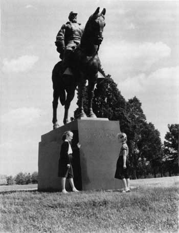

|
| ||
| <<< PREVIOUS | CONTENTS | NEXT >>> |
|
Battling for Manassas ©1998, Pennsylvania State University Press adhi/chap3.htm — 01-Apr-2001 | ||