|
National Park Service
A Survey of the Recreational Resources of the Colorado River Basin |

|
Chapter IX:
DINOSAUR NATIONAL MONUMENT
Dinosaur National Monument was originally established as an 80-acre area by proclamation of President Wilson on October 4, 1915, under authority of the Antiquities Act, for the purpose of preserving a rich deposit of fossilized dinosaur bones found here in an excellent state of preservation. By proclamation of July 14, 1938, signed by President Franklin D. Roosevelt, the area was extended to include other resources of great scientific interest, such as the canyon of the Yampa River and the Canyon of Lodore, Whirlpool Canyon, and Split Mountain Canyon on the Green River. The total area, including State and private lands within the exterior boundaries, as of October 1945, is approximately 209,744 acres.
LOCATION
The monument lies in semiarid northwestern Colorado and northeastern Utah; about 70 percent falls within Colorado and 30 percent in Utah. It is essentially a canyon-plateau area. Earth processes of a past geological age with contemporaneous biological developments of a spectacular nature have produced its outstanding features. It lies on the southern flanks of the eastern end of the great east-west Uinta Mountain uplift. While there are other notable geological, wilderness, and scenic values in the vicinity, the monument is, from the standpoint of such values, the spectacular core of a considerable region on the Upper Colorado River Basin. Between the northern end of the monument and the Utah-Wyoming State line are noteworthy canyons on the Green River, such as Red Canyon and Flaming Gorge. Fine as they are, they do not possess such exceptional qualities as are present in the monument.
SCIENTIFIC, SCENIC, AND RELATED VALUES OF THE
MONUMENT
Functionally, the monument consists of two contiguous units which will be referred to as the Quarry Unit and the Canyon Unit. The comparatively small Quarry Unit, comprising three or four thousand acres, includes not only the 80 acres of the original national monument, but also surrounding land west and north of the Green River and south of Split Mountain. The Canyon Unit, consisting of about 206,000 acres, comprises the rest of the monument. Operationally, the monument is split into three distinct units of roughly equal size by the virtually impassable canyons of the Green and Yampa Rivers.
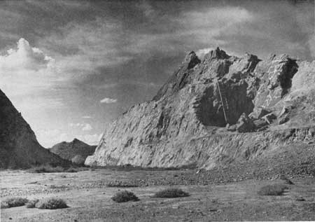
Quarry Unit.—The most remarkable single feature of the monument is the world-famous dinosaur fossil deposit in the Quarry Unit. The fossils are found in the Morrison formation (upper Jurassic) on the south limb of the Split Mountain anticline. This formation underlies the shales and sandstones of the Cretaceous, and is underlain by other strata of the Jurassic. Below the Jurassic lie the "red beds" of the Triassic group. In the vicinity of the "Quarry," the strata of the Cretaceous, Jurassic, and Triassic dip sharply to the south. Extensive excavations have been carried out, and considerable removals of important fossils have been made. It is to be expected that the unexcavated parts of the formation at the "Quarry" are just as rich in quality and variety of fossil specimens as was the excavated part.
|
| Figure 110.—Dinosaur Quarry—Dinosaur National Monument. |
|
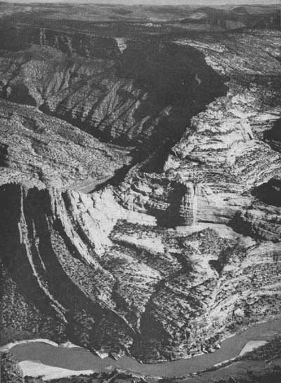
| Figure 111.—Green River Canyon from Harpers Corner in Dinosaur National Monument. The river is 2,400 feet below observer. |
Near the "Quarry" the upturned sedimentary rock formations tell a geological story of events preceding and following the era when dinosaurs roamed over a landscape much different from that of the present. The tilted rocks exposed in the Quarry Unit are part of the thousands of feet of strata that have been raised in an anticlinal fold parallel to and south of the main east-west trending Uinta Mountain uplift. The view from the hills above the fossil bed is worthy of recognition. There, in the presence of the evidence of the most spectacular biological development of the past, one may contemplate the future.
Because of its paleontological values, the Quarry Unit justifies its inclusion in the National Park System.
Canyon Unit.—Geological and scenic values are of predominant importance in the Canyon Unit. Here the folded and faulted sedimentary rock formations have been cut by the deeply intrenched meanders of the Green and Yampa Rivers. The dynamic process of river erosion has produced a colorful, rugged wilderness of deep canyons, dissected erosional benches, and bold promontories.
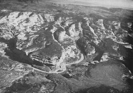
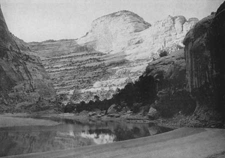
The precipitous Canyon of Lodore on the Green River, which is upwards of 2,700 feet deep near Triplet Falls, has been cut in quartzites, sandstones, limestones, and shales, some of them characterized by deep reds and purples. It possesses an exceptional degree of grandeur. The Yampa River Canyon, whose course is marked by deeply intrenched meanders, here and there separated by narrow promontories, has been cut in sandstones and limestones. Its walls are often sheer and, in the vicinity of Warm Springs Draw, rise about 2,000 feet above the Yampa. One of the more notable parts of Whirlpool Canyon is the section downstream from Sage Creek, where the river has cut through the side of an abrupt mountain fold, leaving a relatively thin outer shell or crust of fold standing as the north wall of the canyon. The Split Mountain Canyon is of interest for the way in which the river has cut along the middle of the fold, about on its axis. All of the canyons possess notable scenic qualities.
Jones Hole, Echo Park, and Castle Park are three of the more noteworthy, relatively small areas of the monument. Jones Hole and Echo Park contain perennial clear streams. The three areas are walled by high cliffs. In Echo Park at the junction of the Green and Yampa Rivers, and in Castle Park at the junction of Hell Creek and the Yampa, the cliffs are of Weber sandstone. In Jones Hole, they are of limestones and sandstones along Ely and Jones Hole Creeks. In each case, a feature unusual in this region is the relative abundance of deciduous cover.
In addition to the predominant geological, scenic, and wilderness values of the Canyon Unit, there are distinct though relatively minor biological interests. Deer are numerous in most sections; mountain sheep are present, though rarely seen. The vegetative cover embraces a variety of plant habitats, in life zones ranging from Upper Sonoran (mixed desert shrub and juniper-piñon) through Transition into Boreal (aspen, lodgepole, and fir). There are many plant associations correlated with geological structure, and many interesting biotic units whose origins are related to the development of the canyons and the local mountain structures on the flank of the Uinta Mountains.
Varied and frequent evidences of primitive Indian occupation constitute the archeological exhibit. Evidences of prehistoric Indian life are found in many sectors—in highlands, on benches between highlands and canyons, in canyons, and in valley bottom "parks" such as Castle Park, Hardings Hole, Pool Canyon, Echo Park and Island Park. They include petroglyphs, camp sites, rock shelters, middens, and caves that were inhabited or used for storage.
Variety in the characteristics of the Canyon Unit is a quality of exceptional importance. Geological exhibits of sedimentation, and stratigraphic, structural, and physiographic features are of prime significance. Second only to them are the conspicuous aspect of wildness and the scenic values which so often form an inseparable combination with those of geology. The Canyon Unit is of national importance for its geological and wilderness values. It is notable and distinctive, and in its present, unaltered state, warrants its existence in the National Park System.
RECREATIONAL VALUES OF THE
MONUMENT
To date, the monument has received a minimum of planned development. Access to the Quarry Unit is provided, but no provision for public access into the Canyon Unit has been supplied. Such access to the latter as exists is by way of low-standard roads which are used by ranchers in the locality. Recreational utilization of the monument, save for the part centering around the quarry, is negligible at present.
Recreational values exist, though they are undeveloped. The area offers excellent possibilities for the layman to see and learn interesting stories of the land forms and the plant and animal life of past geological periods, the early occupation by man, and the present plant and animal life. Over most of the monument the geological features—the thick sequence of rock formations of Paleozoic and Mesozoic ages, the structural folds and faults, and the rugged relief blend with the scenic features and the wilderness characteristics to form a setting which offers many opportunities for education, spiritual uplift, and physical recreation, including camping, boating, horseback riding, hiking, and fishing.
PROPOSALS BY THE BUREAU OF
RECLAMATION
Potentialities for using the water resources of the Green and Yampa Rivers within and near the national monument are being studied by the Bureau of Reclamation. Under consideration are proposals for the Echo Park and Split Mountain Dams, reservoirs, and appurtenant facilities.
Echo Park Dam and Reservoir.—The proposed site of the Echo Park Dam is in the narrow inner gorge of the Green River at a point near the base of the tip of Harpers Corner. Normal stream elevation at this point is about 5,048 feet. At high water, currently being considered for elevation 5,550 feet, the reservoir would run throughout the length of the Green River Canyon within the national monument upstream from the dam, and would extend northwestward from the north boundary, through Browns Park, for a distance of 30 miles or more by river. Another arm of the reservoir would lie in the Yampa River Canyon, and would extend to a point in Lily Park east of the eastern boundary of the monument.
Maximum drawdown might amount to 150 feet during periods of extreme drought. High-water levels could be expected to take place normally during July and August, with relatively high levels in September. Low water ordinarily would occur during the late winter months before spring run off. Seasonal variation would be from 20 to 50 feet.
The Bureau of Reclamation has not made a decision on the height of the dam, location of construction roads, construction camps, or power lines. It is planned to open a gravel pit in Island Park.
Split Mountain Dam and Reservoir.—The proposed site of the Split Mountain Dam lies near the head of Split Mountain Canyon. A dam 118 feet high to raise the water surface to an elevation of 5,048 feet is being considered. A reservoir at that elevation would inundate Little, Rainbow, and Island Parks, and the bench land at the mouth of Jones Hole. Present studies indicate practically no fluctuation either seasonally or annually. Only in years of extreme drought would there be any radical lowering of water level.
The Bureau's report of March 1946, on the Colorado River Basin states: "A power head of 200 feet could be utilized by means of a pressure tunnel in three sections, extending from the dam 8.3 miles downstream to a power plant 5 miles up the river from Jensen, Utah."
|
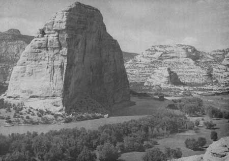
| Figure 112.—Steamboat Rock, Echo Park, and the Green River. |
|
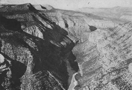
| Figure 113.—Whirlpool Canyon—spurs of Wild Mountain at left; Zenobia Peak is the high point on skyline (right); and Echo Park Dam site is in the narrow inner gorge. |
EFFECTS OF PROPOSED DAMS, RESERVOIRS, AND
RELATED STRUCTURES UPON NATIONAL MONUMENT VALUES
Echo Park Dam and Reservoir.—Information to date indicates that the Echo Park Dam, reservoir, and appurtenant structures and facilities would not affect the Quarry Unit of the monument. They would, however, seriously and adversely affect the Canyon Unit. The dam would be totally alien to the geology and landscape of the monument. It would be seen from the upper end of Whirlpool Canyon and from points along the rims of the canyon, and, from the viewpoint of monument values, would be a lamentable intrusion.
Power lines would have a widely damaging effect upon wilderness and scenic values. Development of a power project would require the introduction of construction and operation roads and other facilities which would otherwise not be built. They could hardily be constructed without injury to geological and scenic values of the Canyon Unit.
Far-reaching effects upon scenic, geological, and wilderness values would result from impoundment of the Echo Park Reservoir. The two-arm artificial lake would cover wholly or in part a number of fine geological exposures, would reduce the visible height of canyon walls, and would substitute long bodies of still water, widening here and there into bays, for the characteristic rivers and fringing vegetation which now lie in canyon bottoms. The Canyon of Lodore would contain a narrow fiord-like lake which would inundate a portion of the exposed geological formations in the canyon bottoms. The same is true of the Yampa Canyon.
Particularly deplorable effects of the Echo Park Reservoir upon geological and wilderness features would occur in the localities of Pats Hole and Echo Park near the junction of the Green and Yampa Rivers and in Castle Park and Hardings Hole on the Yampa River. A large part of Pats Hole would be covered by the Echo Park Reservoir. The fine spring and Pats Cave where the interesting character, Pat Lynch, lived alone for many years, would be submerged. Even more unfortunate, would be the submersion of the floor of Echo Park, the great reduction in the visible height of the nearly vertical sandstone walls of Echo Park which rise several hundred feet above the floor, the inundation of about one-half of Steamboat Rock, and partial obliteration of noteworthy folds and faults so strikingly revealed in this area.
Split Mountain Dam and Reservoir.—A dam at the head of Split Mountain Canyon would detract materially from the geological and wilderness values of the entrance to the canyon. Construction operations would unavoidably cause some permanent scarring in the locality of the dam site.
From the viewpoint of natural values, the Split Mountain Reservoir would adversely affect Little, Rainbow, and Island Parks. The cluster of islands in the river and the pleasant bottoms of brush, grasses, and fringing cottonwoods would be replaced by a large lake of three bays. The rushing river with its rapids and whirlpools in Whirlpool Canyon above Island Park would be replaced by a long, narrow body of still water.
At the time this report was prepared, data were not available to the National Park Service from which to determine whether construction of a pressure tunnel from the Split Mountain Dam to a power plant 5 miles upstream from Jensen would affect the Quarry Unit.
Concerning transmission lines, comments relating to the Echo Park project apply generally to the Split Mountain proposal.
Other effects.—Submersion of parks and the bottoms and slopes of canyons and entering draws undoubtedly would affect adversely the existing biota of the area. A number of interesting archeological sites would be submerged, particularly in the vicinity of Echo Park, Castle Rock, and Hardings Hole along the Yampa River.
Summary.—Construction of the Echo Park and Split Mountain Dams, reservoirs, and related temporary and permanent facilities would materially and deplorably alter the dominant geological and wilderness qualities and the relatively minor archeological and wildlife values of the Canyon Unit of Dinosaur National Monument. Its present scenic and scientific values and its wilderness character would be seriously altered. On the other hand, creation of the proposed Echo Park and Split Mountain Reservoirs would undoubtedly produce other recreational opportunities.
POLICY AND PLAN FOR THE NATIONAL
MONUMENT
In accordance with the Congressional Act of 1916 creating the National Park Service, it has been and is the responsibility of the Service to conserve the scenery and the natural and historic objects and wildlife within the areas in the National Park System, and to provide for the enjoyment of them in such manner and by such means as will leave them unimpaired for future generations. Accordingly, the major aims of the National Park Service in its administration of the Dinosaur National Monument are:
1. Protection of unimpaired resources and, through elimination of factors that have modified other natural conditions, the restoration of those other conditions to their original state. The modifying factors principally involved are agricultural pursuits which consist largely of grazing, and the presence of non-Federal lands within the exterior boundaries of the area.
2. Protection and preservation of archeological features.
3. Provision of such facilities as are necessary to enable visitors to study and enjoy the features of paleontological, geological, wilderness, and related interests, and as are required for proper recreational use and administration of the area.
CONCLUSIONS
The policy of the National Park Service, as the administrative agency now primarily responsible for the national monument, has been, and is, to make the protection of the natural and archeologocal values of the area the controlling factors in administering it. The question of whether this policy is to be changed to permit water uses will require for its solution a review of all probable advantages and disadvantages arising from such use.
Dinosaur National Monument is eminently qualified, in the absence of very strong special reasons to the contrary, to justify its retention as a unit of the National Park System. Certain parts of it should be made reasonably accessible by road and accommodations provided for visitors just as soon as funds become available. Before authorization is given to develop its water resources and to recognize water use as the principal consideration in the administration of the Canyon Unit, it should be clearly shown (1) that economic and social values deriving from such development and use would largely and certainly exceed the economic costs of producing them; (2) that it would be more economical to develop the water resources of the monument rather than other resources available for the same purpose within practicable reach; and (3) that it would be of greater benefit to the whole Nation to develop the area for water storage and power than to retain it in a natural state for its geological, wilderness, and associated values for public enjoyment.
|
| Figure 114.—Meanders of Yampa River near its junction with the Green River. |
|
| Figure 115.—Yampa River Canyon. |
|
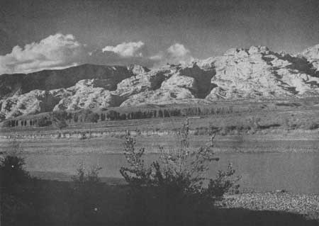
| Figure 116.—Split Mountain from the banks of the Green River. |
| <<< Previous | <<< Contents>>> | Next >>> |
colorado-river-basin/chap9.htm
Last Updated: 06-Sep-2004