|
National Park Service
A Survey of the Recreational Resources of the Colorado River Basin |

|
Chapter VI:
POTENTIAL RESERVOIRS
The survey of the recreational resources of the Colorado River Basin involved the consideration and investigation of about 135 potential reservoir sites. (Plate 15 in pocket.) The object of the investigation was to ascertain, at least in a preliminary way, the character of the area which would be flooded or affected by the reservoir; the recreational and scientific importance of the scenic, historic, geologic, archeologic, or biologic features of the reservoir area; the effect the potential project would have on important existing features; and the potential recreational values of the reservoir area.
In most instances, project plans had not been completed for the dams and reservoirs, and in many cases the only information available at the time was the approximate location and purpose of the dam and the size of the reservoir. Hence, it was not possible to make a final appraisal of the potential recreational values of the reservoir. Generally, however, it was possible to determine whether important recreational features existed in the reservoir area and whether the potential reservoir would or could have recreational values.
In a number of cases, particularly in regard to smaller reservoirs, the recreational potentialities of the site will be increased considerably if, as the project investigations progress, it is found possible to provide a dead storage or conservation pool.
For convenience in planning the development of the water resources of the Colorado River Basin, the Bureau of Reclamation has divided the basin into seven main divisions suggested by physical characteristics. The same divisions are used in the following discussion.
GREEN RIVER DIVISION
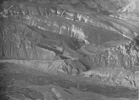
Upper Green River Basin.—In the Upper Green River Basin, the Flaming Gorge, Red Canyon, Fontenelle, and Kendall Reservoir sites appear to be of most importance for recreation. The mile-long Flaming Gorge of the Green River is unusually colorful but it is not unique or outstanding in comparison with the colorful scenery found farther down the Green River. However, the combined scenic and geologic interest of Flaming Gorge, the nearby Horseshoe Canyon, and the canyons of Sheep Creek, plus the proposed reservoir would make this section of considerable recreational value. There is certain to be a demand for recreational facilities in the vicinity of the dam and at one or two points up the reservoir to serve people traveling through the region and those living in the vicinity of Green River, Wyo.
The Red Canyon Dam site, 31 miles below Flaming Gorge, is also in the scenic country on the north side of the Uinta Mountains. With the Flaming Gorge Dam the Red Canyon Reservoir should be fairly free of silt and should offer good fishing possibilities. The sheer walls of the canyon, however, greatly limit the possible use of the reservoir for recreational purposes.
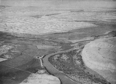
The Fontenelle and Kendall Reservoirs on the Green River in Wyoming would be primarily of local recreational interest, but would receive some tourist use because of the proximity of United States Highways 189 and 187.
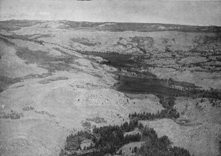
Most of the other potential reservoirs lie in the open sagebrush plains and hills and would offer little in the way of recreational attractiveness because of summer drawdown and lack of cover. Burnt Lake, lying within the Bridger National Forest, is notable for its natural scenery and its nearly complete freedom from artificial development. Alteration of the water level, as has been proposed, would ruin the scenic and recreational values of the lake.
|
| Figure 51.—Flaming Gorge—looking down Green River to dam site. This is where the Green River starts cutting through the Uinta upwarp. |
|
| Figure 52.—Fontanelle Reservoir site—looking upstream from dam site. |
|
| Figure 53.—Burnt Lake on the west slope of the Wind River Range. |
|
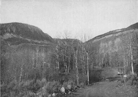
| Figure 54.—Hades Reservoir site—looking up the Duchesne River Valley. |
Yampa and White River Basins.—The Juniper and Upper Bear Reservoir sites are conveniently located to serve the more populated sections of the basin. With some development of recreational facilities and fishing, they should be popular with the local people and those traveling through the region. The other reservoir sites are situated in sparsely populated areas and would have little effect on the recreational resources of the basin.
Uinta Basin.—The two potential dam and reservoir projects, Echo Park and Split Mountain, will effect Dinosaur National Monument. These projects are discussed in Chapter IX.
The many good lakes and streams in the Uinta Mountains lessen the need for water recreational areas in the adjoining Duchesne and Ashley Valleys. However, the proposed Pelican Lake, Starvation, Stanaker and Red Creek Reservoirs should have some local recreational value. Crow Creek, in a remote location, would probably receive little use. The Hades site is on one of the main approach roads to the High Uintas Primitive Area. The proposed reservoir development would not compensate for the loss of the present recreational assets. The enlargement of Strawberry Reservoir is not likely to increase its present recreational values unless the percentage of drawdown on the enlarged reservoir is less than that of the present one.
Price and San Rafael River Basins.—This section lacks natural water areas suitable for recreational use. Hence, all of the sites, except perhaps the Buckhorn which is in desert country and would be subject to complete drawdown, should be planned for recreational use by the residents of the nearby irrigated districts. The Mammoth and Joes Valley sites in the Manti National Forest at fairly high elevations appear to offer the best possibilities.
The two large potentialities in this subdivision are the Desolation and Rattlesnake Dams located in the remote and almost inaccessible canyons of the Green River. The reservoirs formed by the two dams would extend from a few miles north of Green River, Utah, almost to Ouray, Utah. The main access of the reservoirs would be from these two towns. Although the reservoir areas have only been investigated from the air, it is doubtful that the scenic or recreational values, either existing or potential, will be found important. Present information indicates that scenically this section does not compare with sections along the Green above Jensen, Utah, and below Green River, Utah. Some archeological sites of importance have been found in side canyons, indicating that an archeological survey of the reservoir areas should be made well in advance of the completion of these projects.
GRAND DIVISION
Of all portions of the Colorado River Basin, the Grand and San Juan divisions have the best natural water areas and the least need for artificial lakes. However, with the great number of tourists attracted to the region, additional water bodies that do not interfere with or eliminate existing recreational resources should be of considerable benefit. The McPhee and Dewey Reservoir sites are well located to provide new recreation areas. A number of other sites might provide opportunities for local use such as Castle Creek, Gurley, Rabbit Ears, East Troublesome, Barbers Basin, Fourmile No. 4, Rifle Gap, Tomichi, McDonough, Grand View, Finch, Cottonwood, Miramonte, Buckeye, Mill Creek, Coyote, East Canyon, Owens Creek, Vega, Castle, and Gorsuch. The last four sites, however, will have to compete with the lakes and reservoirs on top of Grand Mesa for attendance and use.
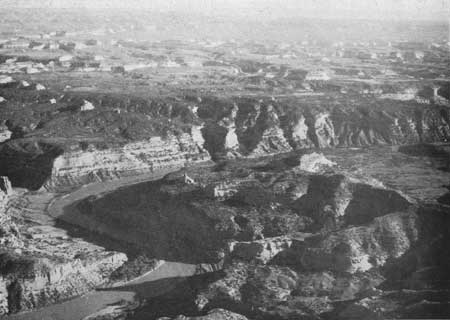
The Dewey Reservoir site is on the Colorado River, in eastern Utah and western Colorado and about midway between the north and south boundaries of the two States. By far the greater part of the reservoir site, which is more than 40 miles in length, lies in Utah. Only a small portion of it extends into Colorado. The tentative dam site is about 30 miles upstream from Moab, Utah, at the upstream end of the spectacular Red Canyon of the Colorado River that lies between the dam site and United States Highway 160 near Moab.
The purpose of the proposed project is the development of hydroelectric power. Preliminary studies by the Bureau of Reclamation indicate a water surface of about 66,000 acres at full reservoir and about 21,000 acres at dead storage. Maximum drawdown, which normally would occur during the winter months, would be about 106 feet.
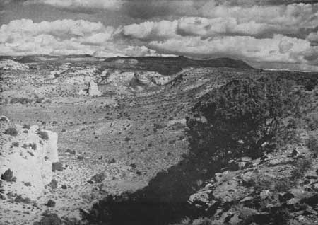
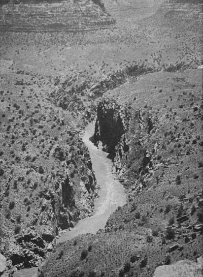
Lands involved include State school lands, privately owned lands, and public domain. The greater part of the area is semi-desert grazing land having little scenic or recreational value. However, in the vicinity of the Dewey Bridge there are distinctive sandstone cliffs and box canyons, and the canyon of the Dolores River which enters the Colorado River about a mile and half above the dam site is colorful and interesting. The Westwater Canyon of the Colorado River, the principal scenic feature of the reservoir area, is about 12 miles long and several hundred feet deep. Deep tributary canyons enter on its easterly side, and both the main and tributary canyons are characterized by sandstones that have a pleasant reddish hue. Views from the west rim are good, particularly in the Big Hole section, and from the air the Westwater Canyon and the numerous and intricate side canyons on the east form a notable scene. When compared, however, with some other areas on or near the Colorado River in the same general region of eastern Utah and western Colorado, such as the Colorado and Arches National Monuments, the canyon of the Colorado River between Dewey Bridge and Moab, and the amazing landscapes near the junction of the Green and Colorado Rivers, the Westwater Canyon is clearly of secondary scenic importance.
The proposed reservoir would be a large lake of very irregular shore line, and because most of the area it would cover slopes somewhat gently toward the Colorado River, drawdowns would expose considerable amounts of unsightly bottom. In the locality of the Dewey Bridge, where at full reservoir the water would be approximately 290 feet deep, a good deal of the colorful sandstone would be submerged. In the vicinity of the Big Hole portion of Westwater Canyon, the reservoir at high-water level would be about 200 feet deep, materially altering the appearance of the canyon by reducing its apparent depth and substituting a still body of water for the rapidly flowing river. Nevertheless, the canyon would retain some of its scenic value, and recreational resources would be addled, because the lake would offer opportunities for boat trips, fishing, swimming, and camping.
|
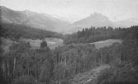
| Figure 55.—Castle Creek Reservoir site north of Gunnison, Colo. |
While the Dewey Reservoir would not be of special recreational importance to the immediate vicinity since the local population is very sparse, the lower portion would be of some recreational usefulness to residents of Moab, and the Westwater Canyon would be of interest to travelers using United States Highway 50 and to residents of the Grand Junction area, provided it were made reasonably accessible.
It has been indicated by the Bureau of Reclamation that a road for construction purposes would have to be built from United States Highway 50 and the Denver and Rio Grande Western Railroad to the dam site. It is recommended that this be built as a permanent road, to connect with the unsubmerged portion of Utah State Highway 128 between the dam site and United States Highway 160 near Moab. This would, in effect, retain the present route from Moab through the spectacular Red Canyon of the Colorado River to United States Highway 50, which not only is used as a short cut from Moab to Grand Junction, but affords access to the remarkable spires and buttes of this part of the Colorado River Canyon.
Consideration should also be given to providing access by automobile from United States Highway 50 to a limited recreational development at the Big Hole. Provision for boat trips in the canyon would be desirable. Public control of the reservoir shores and of the Big Hole would also be desirable.
The area to be inundated is reported to contain several archeological sites and exposures of fossilized dinosaur bones. Fragments of petrified wood are abundant. While it seems doubtful that any unmolested archeological sites remain to be discovered, it is recommended that an archeologist investigate the area well in advance of reservoir construction in order to record any important sites that would be inundated. It is also recommended that the paleontology of the area be similarly investigated.
|
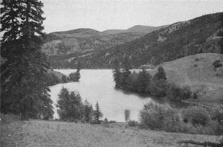
| Figure 56.—Lake San Cristobal near Lake City, Colo. |
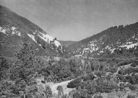
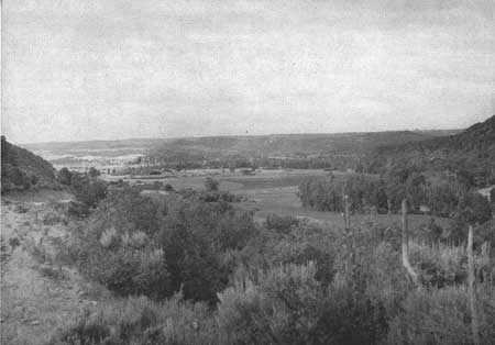
The McPhee Reservoir site is in the beautiful Dolores River Valley, a short distance downstream from the town of Dolores, Colo. The natural conditions are ideal for creating an artificial lake of considerable beauty and recreational value. Fishing is good in the upper sections of the Dolores River and should be good in the reservoir. This section of the Dolores Valley is now used for picnicking, camping, and fishing, and with the reservoir these uses should increase. There were 12,421 people living within easy access of the site in 1940. It is recommended that plans for development of the area include acquisition of all the shoreland and the provision of recreational facilities for public enjoyment of the reservoir including boat docks, swimming beach, picnic areas, camping areas, and the relocation of the present road through the proposed reservoir area to maintain the scenic drive down the Dolores Valley.
|
| Figure 57.—Dewey Reservoir area—typical terrain of east side north of Dolores River. |
|
| Figure 58.—Westwater Canyon of Colorado River at Big Hole—Dewey Reservoir area. |
|
| Figure 59.—Canyon of Colorado River near Colorado-Utah State line. (Air photo) |
|
| Figure 60.—McPhee Dam site—looking down Dolores River Valley. |
|
| Figure 61.—McPhee Reservoir site—all the lowland in picture would be flooded. |
Other reservoir sites.—Among the sites in the Grand Division that are probably more valuable for recreation as they exist than if dams were constructed are the attractive Eggleston Lake, Lake Brennan, and Lake San Cristobal, and the scenic locations in which Beaver and Banana Ranch Reservoir sites are situated. Missouri Heights Reservoir, as it exists, offers some possibilities for recreation that would not be increased if it were enlarged. The Sapinero Dam would flood a 20-mile section of the extremely popular Gunnison River fishing area and substitute a still-water area which probably would not compensate for the loss of the stream. A dam at the Moab site, just above the Moab Highway Bridge, would eliminate the only scenic drive through one of the impressive canyons of the Colorado River in Utah. The present character of the canyon is undoubtedly more of a recreational asset than reservoirs would be in this location. Several other sites in the Grand Division may not create new values or interfere with existing values. In general, the transmountain diversion projects in Colorado probably will be to the detriment of the recreational values of the region in which they are located. The necessary canals in most cases will cut into attractive mountainsides, and water diverted from the natural channels will decrease the amount available for fishing and other uses downstream.
Special studies should be made of the recreational possibilities of areas like Whitewater during the planning stages to insure the maximum benefits.
SAN JUAN DIVISION
This division includes the San Juan River drainage and the western tributaries of the Colorado River between the junction of the Green and Colorado Rivers and Lees Ferry. The major dam and reservoir proposals in this division, Glen Canyon and Dark Canyon Dams in the Colorado River and the Goosenecks, Slickhorn, and Great Bend on the San Juan, are discussed in Chapter VIII.
The Bluff Dam in the San Juan River, 12 miles below Bluff, Utah, would create a reservoir with a maximum surface area of 28,500 acres and a minimum area of 7,800 acres. Since the reservoir would be located in a region of very sparse population and is to serve primarily for silt retention and flood control, it is not likely to have much value for recreation. The natural scenic attractions in southeastern Utah and northeastern Arizona will, no doubt, appeal more to the tourists than will this reservoir.
Of the other 24 potential sites in this division the O'Neal Park, Howardsville, Hermosa Park, and Mill Meadow sites seem to offer the best possibilities for recreational development and use. They can be definite assets to the recreational resources of the division. O'Neal Park site is in an open, high, mountain valley easily accessible from Pagosa Springs, Colo., and United States Highway 160.
The Howardsville site is a short distance up a deep valley from Silverton, Colo., at an elevation of 9,700 feet above sea level. The reservoir could be developed in conjunction with the old mining town of Silverton into an impressive high mountain resort area.
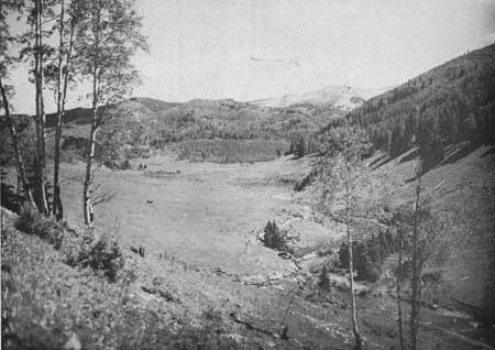
Hermosa Park is an attractive basin about 5 miles long and one-half mile wide, bounded on the west and north by mountains which rise to more than 12,000 feet above sea level. A lake occupying part of the basin would add to the numerous existing recreational assets of the region if the preliminary plans for the project providing for a complete drawdown can be changed to include a substantial dead storage pool.
|
| Figure 62.—Hermosa Park Reservoir site north of Durango, Colo. |
A reservoir at the Mill Meadows site on the Fremont River below Fish Lake could add materially to the recreational assets of that popular summer vacation region.
The proposed Silverton, State Line, Meadows, Monument Rocks, Recapture, Torrey, and Escalante Reservoirs would probably be of local value only. Two natural, high mountain lakes having existing values that would be impaired by enlargement are Emerald Lake and Divide Lake. Other reservoir developments that would probably be detrimental to existing recreational values would be at the Navajo, Blanco, West Fork, Lemon, and Teft sites. Aside from the consideration of archeological values, reservoir construction at the other sites would not affect the recreational picture.
The San Juan Division is rich in archeology and surveys of the reservoir area should be made well in advance of construction of the dams.
LITTLE COLORADO DIVISION
Of the five potential reservoirs in this division, the Forks site located near Holbrook, Ariz., and Petrified Forest National Monument offers the best possibilities for recreational development and use. Preliminary plans call for a reservoir having ban average water surface of 4,300 acres with a maximum fluctuation in water level of only 10 feet. The reservoir area should include a protective strip of land around the entire lake and a suitable area for public recreational use.
Though the other reservoir projects are not likely to be of recreational importance, they are located in a region rich in archeological remains. Archeological surveys should be made of the reservoir areas well in advance of construction operations.
VIRGIN DIVISION
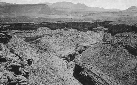
The Virgin City Reservoir site on the Virgin River near Zion National Park is suitable for the development of an important water recreation area that will supplement the scenic attractions of the park. Many of the visitors to Zion National Park and the people living in the valley would use the reservoir for picnicking, camping, swimming, fishing and boating. The proposed Lower Gunlock Reservoir on the Santa Clara River in Utah and the Delmue Reservoir near Pioche and Caliente, Nev., should be attractive to the people living in the vicinity.
|
| Figure 64.—Virginia City Dam site—most of the land in the middle distance would be flooded. Towers of Zion National Park in background. |
BOULDER DIVISION
The two major proposals in this division, Marble Gorge and Bridge Canyon Dams, are discussed in Chapter VII. The site for the proposed Coconino Dam is in the canyon of the Little Colorado River 8 miles below Cameron, Ariz. Cameron, an Indian trading post and tourist court, is on United States Highway 89, near the junction of that highway and the east entrance to Grand Canyon National Park. The proposed dam, rising 260 feet above bedrock, would create a reservoir having a maximum surface area of 36,000 acres and a minimum surface area of 1,000 acres, with a 40-foot difference in water levels between the two.
Considering that there will be a wide variation in water surface area, that the primary purposes of the reservoir are silt and flood control, and that there is not likely to be good fishing, the reservoir will have little recreational use.
The other two potential reservoirs in this division are the Alamo on the Bill Williams River and the Sentinel on the Gila River. Both reservoirs are proposed for flood and silt control. Due to the sparse population of the region and the uncertain flow of the rivers, these reservoirs probably will have little or no recreational value.
GILA DIVISION
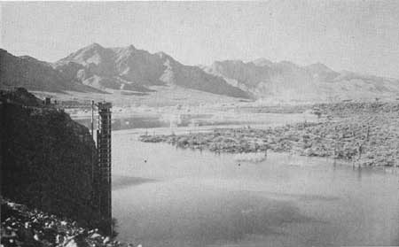
All of the proposed reservoirs in the Gila Division will have some recreational use because of the absence of natural lakes in this important recreational region. Each reservoir should be planned and developed to provide for as much recreational use as is possible consistent with the primary use of the water. The McDowell and Horseshoe sites are suitable for the development of important recreational areas serving the Phoenix metropolitan district. The Buttes Reservoir would serve the Florence area; Box Canyon, the Wickenburg area; and Charleston, the Tucson-Bisbee area.
|
| Figure 65.—Horseshoe Reservoir site in Verde Valley, Ariz. |
| <<< Previous | <<< Contents>>> | Next >>> |
colorado-river-basin/chap6.htm
Last Updated: 06-Sep-2004