|
|
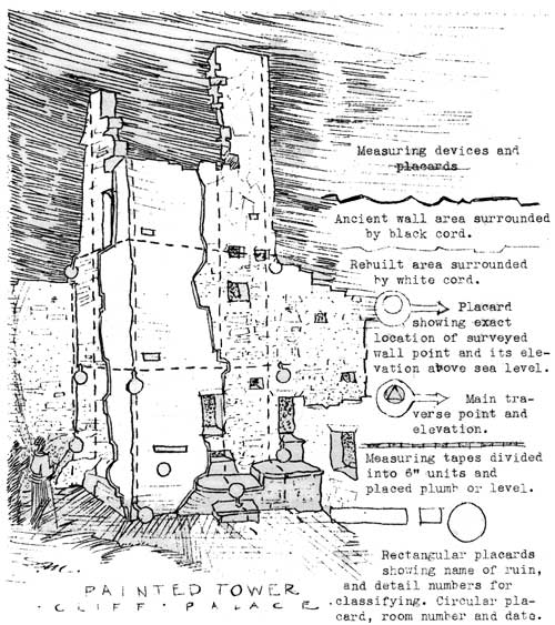
One of the important lures of Mesa Verde is that the tourist may be taken through the ruins over the same thorofares once traveled by the ancient inhabitants. They may look over the original parapets into the canyons below and listen to the ranger's historical and archaeological information about the objects actually before them. A concern of this and other administrations at Mesa Verde has been the preservation of the Pueblo and Cliff Dwellings as nearly as possible in their ancient state so that, as time goes on, the traveling public will be lured by their same unchanged antiquity. Some years ago, Department Archaeologist, Jesse L. Nusbaum and former Superintendent C. Marshall Finnan realized the necessity for a complete survey of the excavated ruins within the Park. The data obtained to be used as authentic source material in connection with the preservation and repair of the ruins. The method developed should also be used in recording excavations in the future. The project was begun in 1933 by Mr. Lyle E. Bennet, who mapped Spruce Tree House. When he had finished Spruce Tree House he realized that some very important items—such as stone texture, plaster texture, actual position of random stones, etc.—could not be recorded satisfactorily or economically in drawing. The writer was appointed January 20, 1934 to continue Mr. Bennet's work. Photographs of each wall and detail were suggested to supplement the drawings. One of the most important phases of the survey is to distinguish between ancient and repaired or restored masonry. This requires an expert knowledge of aboriginal methods in laying walls, and also of the conditions of the buildings during and after the time of their desertion. The study becomes an inventory of the ancient walls and details. The record obtained includes an accurate ground plan of the ruin showing ancient trails and modern tourist routes, photographs of every wall and detail and a typewritten description noting the state of repair, the archaeological and architectural character. References will be shown to main publications, pre-restoration photographs, and to drawings and photographs of the present survey. The picturesque irregularity and lack of true geometric form in the ruins have necessitated the design of a mapping method more comprehensive than the usual measured drawing type. Through the use of measuring tapes and placards placed on the ruins, photographs have been substituted for measured elevation drawings. The photograph becomes a "measured photograph" recording accurately dimensions as well as the texture of the stone work, character of details, et cetera. The survey points located in plan view are printed on placards and photographed in place as part of the "measured photograph".
One thousand photographs of Cliff Palace will be necessary to record every floor, wall and detail. One half the time and money will be used in obtaining this kind of a record as against the usual measured drawing procedure which in the end could not be as accurate. Cliff Palace is the largest Cliff Dwelling on the Mesa. The present survey program includes Cliff Palace, Balcony House, Square Tower House, New Fire House, Sun Temple and Far View House. Public Administration Funds have made this much needed survey possible. | ||||||
| <<< Previous | > Cover < | Next >>> |
vol5-1g.htm
14-Oct-2011