|
|
The excavation of Sun Temple, in Mesa Verde National Park, by J. Walter Fewkes1, in 1915 brought to light a most unique type of building that promised to add much to the knowledge of the Mesa's prehistoric inhabitants. The mound resting on the point of the finger-like mesa formed by Cliff and Fewkes canons, directly across from Cliff Palace suggested that it might conceal an ancient ruin. Among the growth of cedar, pinyon and sage brush growing over this mound many artificially worked stones with well-dressed pecked surfaces indicated a Cliff-Dweller Pueblo.
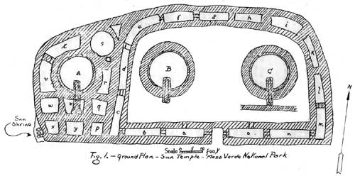
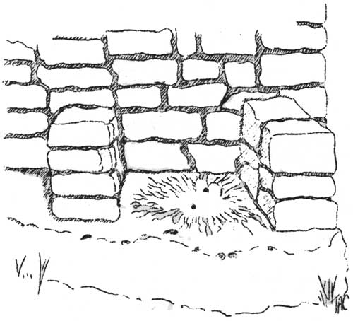
After three months' work on the mound there was brought to light a type of ruin heretofore unknown in a region rich with prehistoric remains. The ground plan as shown in Figure 1 follows, in general, the shape of the letter D. The building appears to be in two sections, the larger, original building forming a complete D-shaped unit and a smaller western addition, which Dr. Fewkes calls the Annex, was constructed so as to continue the original floor plan. Under the southwest corner of Sun Temple a large stone was uncovered on which was discovered a most unusual and peculiar marking. This marked section was enclosed on three sides; on the east by the wall of Sun Temple, and on the north and south sides by two short walls built at right angles to the main building wall. (Figure 2). This structure has, since its discovery, been known as the Sun Shrine and was first described by Dr. Fewkes1 in his publication and also in the Mesa Verde guide booklet2 as follows:
The Fossil Palm Leaf One of the most remarkable features of the structure is a stone fossil set in the outer walls near the southwest corner. Mr. F.H. Knowlton, of the United States National Museum, has identified this as a fossil leaf of a palm tree of the Cretaceous period. The point is that the rayed leaf resembled the Sun and the ancient races were sun worshippers. A natural object resembling the sun would powerfully affect a primitive.
"At all events," says Dr. Fewkes, "They have partially enclosed this emblem in walls in such a way as to enclose the figure on three sides leaving the enclosure open on the fourth or west side. There can be no doubt that the walled enclosures was a shrine and the figure in it may be a key to the purpose of the building. The shape of the figure on the rock suggests a symbol of the sun, and if this suggestion be correct, there can hardly be a doubt that solar rites were performed about it."
This description was continued until 1927 with only slight changes in phraseology. In the fall of 1925 Willis T. Lee visited the Park and, on viewing the markings, was very much perturbed over what seemed to him an erroneous identification. As a result of his expression, the 1927 booklet3 was revised to read: The Sun Symbol "On the upper surface of a large rock protruding from the base of the southwest corner of the building a peculiar impression was found, enclosed by low wing walls on the north and south sides. Although originally identified from a poor photograph as a fossil palm leaf of the Cretaceous period, the late Dr. Willis T. Lee, of the United States Geological Survey, after careful examination, stated that it was the remains of a Cretaceous period spring. The water bubbled up through the unconsolidated sands and in escaping formed the ridges radiating from the bowl. The ancient cliff dwellers were sun worshipper, and a natural object resembling the sun would powerfully affect their primitive minds. Probably for this reason the impression was enclosed as a shrine."
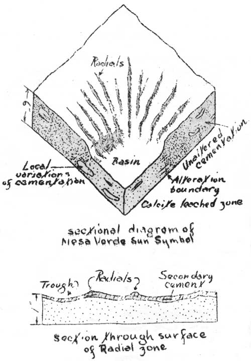
In the fall of 1931, Dr. Walter B. Lang, Geologist, United States Geological Survey, visited Mesa Verde, became interested in the peculiar markings and skeptical of the explanations given above. To him it seemed unlikely that the spring-origin was applicable and his belief was greatly strengthened during his field work in 1932. Dr. Lang found similar impressions in the San Andres limestone near Little Picacho Hill, some 30 miles west of Roswell, New Mexico, and later in the Kaibab limestone on the south rim of the Grand Canyon, behind the Powell Memorial Monument. The writer made an intensive 'search of exposed' sandstone in the Park and located some twenty specimens, similar in markings to the one located at Sun Temple. At the request of Dr. Lang, and with the permission of the National Park Service, a specimen of the Mesa Verde Symbol was sent to Washington for laboratory study. As a general rule these "Sun Symbols" are found along the canyon rims at the southern end of the mesa among the Pinyon and Juniper forest. They are found in one particular brown layer of the Mesa Verde sandstone. This layer, about 4 feet thick, is just beneath the red top soil and is exposed along the rim of the canyons. It is at these exposed places only, that these erosive characters are evident. Dr. Lang's determination is as follows: "When a rock is exposed to weathering, variations in cementation influence the rate of erosion and what may have been a smooth surface soon becomes irregular and pitted. Rain water contains carbonic acid and is a solvent of calcium carbonate. In percolating downwards into the sandstone it dissolves the binding cement and frees some grains that may be removed by wind, water, and other agencies of transportation. The areas of greater permeability are relatively more easily weathered and form hollows that catch surface water, thus becoming pockets or basins (tinajita) that tend to deepen and expand with each ensuing shower. So long as the rocks remain moist and climate relatively humid, downward percolation of rain water is the dominant process, but in the semi-arid southwest another agency of importance comes into play. Here by far the greater amount of annual precipitation falls during thunder showers in the summer months when the air is dry and warm. The porous surface rocks quickly become saturated during one of these downpours, but dry out rapidly after the storm has passed. Some of the absorbed moisture descends to the water table or an aquifer, but most of it in the upper part of the rock is drawn to the surface by capillarity and evaporated and must therefore leave behind at or near the surface the dissolved mineral matter. Where irregularities form, protruding slightly above the general level, more rapid evaporation takes place and therefore more dissolved salts are deposited, thus serving to restrain erosion in those areas. The lower areas accumulate more water, suffer more solution, and acquire less salts. Therefore, a differential action is set up, bringing in to greater relief the initial variations in surface expression.
"When a depression forms, it becomes a center of accumulation. Rills develop upon the rim, extending outward as they conduct more water to the central basin, and deepen to form radial troughs. If the depression deepens rapidly, the radial lines and troughs follow down into the basin as well as grow farther outward. The basin probably soon attains maximum circumference, but deepens more readily than it enlarges. Thus the Sun Symbol mark is the product of erosion on sandstone so constituted as to initiate these surface effects". The Sun Symbol marking usually ranges from 1 foot to 2 feet in diameter. It is composed of two parts—a central well or basin from 1 to 6 inches deep and a border of radial ridges and furrows surrounding the bowl. The figure is usually circular in form and the length of the furrows is about equal to the diameter of the central wall. At their outer ends these furrows blend into the irregularities of the rock surface, but upon approaching the bowl they become more prominent by forming troughs which in some instances are as much as an inch in depth. Near the margin of the bowl the radial ridges and troughs plunge downward at an angle whose steepness depends upon the depth of the bowl. The Sun Symbol looks like a large sunflower impressed in rock. The cutting of a vertical section across one of the Mesa Verde Sun Symbols exposed a buff colored sandstone of even texture composed of angular quartz grains .15 mm. in diameter, cemented by silica with considerable calcium carbonate and hydrous iron oxide. Though hot hydrocholoric acid will remove the iron oxide and calcium carbonate, the silica holds the grains in place. Horizontal stratification is suggested only by slight variations in the cementing materials. On the cut surface splotches one half to three quarters of an inch long are pale buff or whitish from an excess of calcite, whereas other patches are slightly darker brown from a concentration of iron oxide. Most of the coloration areas have gradational boundaries; a few are sharply defined. All have their major axes parallel.
| ||||||
| <<< Previous | > Cover < | Next >>> |
vol5-1e.htm
14-Oct-2011