|
|
|
NATURE NOTES FROM ACADIA
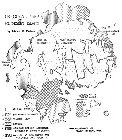
GEOLOGICAL MAP OF MOUNT DESERT ISLAND, MAINE* Edward H. Perkins (Formations indicated on map in order of age). 1. Greenish schists. - The "Bartlett Island series" of Professor Shaler. Sedimentary rocks now altered into highly metamorphosed chloritic schists. Very old. Probably Precambrian. May be the same as the Ellsworth schist of the main land. 2. Bar Harbor sediments. - Slightly metamorphosed sandstones and shales. Deposited in a shallow sea in early Paleozoic time. Exact age unknown. 3. Felsitic lavas. - Two areas on island. One in the northern portion of the island is well exposed at the Ovens. Just east of the Ovens the lava may be seen resting on a floor of Bar Harbor sandstone which has been baked to a hornstone by the heat of the lava. This area was included in the "Bar Harbor Series" in Professor Shaler's map. The second area is in the southern part of the island and is the "Cranberry Island series" of Shaler. These lavas resemble those of the north portion of the island with the addition of beds of volcanic ash indicating explosive eruptions. 4. Hornblende granite. - This granite with hornblende as the dark mineral is the red granite of the eastern mountains. It is intrusive into the lavas and early sediments. 5. Biotite granite. - The western part of the island is covered with a granite like that of the Penobscot Bay region to the west. Biotite is the dark mineral and the granite is gray instead of red. The dividing line comes somewhere near the western margin of Somes Sound but has not yet been mapped in detail. *In early May my wife and I had the privilege of accompanying Dr. and Mrs. Edward H. Perkins of Colby College who, for the thirteenth successive year, were leading a group of students on a geology field trip to Mount Desert Island, Maine. This fruitful and delightful excursion was followed by correspondence between Dr. Perkins and myself in the course of which permission to reproduce his own geological map of Mt. Desert Island was secured. As far as I have been able to discover, this is the most detailed map of its kind ever published, and my wife and I take pleasure in having so important an item appear for the first time in Nature Notes from Acadia. Dr. Perkins' own interpretation of the map appears above. - Ranger-Naturalist
6. Intrusive breccia. - The "Schooner Head series" of Shaler. This is a jumbled mass of diorite, felsite, sedimentary, and granite. The Bar Harbor sediments and assooiated lavas were first intruded by diorite and then by granite, each intrusion breaking and mashing the older formations. It represents the contact zone between the sediments and the diorite to the east and the granites to the west. 7. Complex of sediments, lavas, and granite. - The "Sutton Island series" of Shaler. This area is covered by sediments and lavas intruded by granites. No one type dominates the region. In places the rocks resemble a breccia like that at Schooner Head while in other places any of the rock types may be found unmixed with the others. Note: The legend on the map is numbered to correspond with the above. |
| <<< Previous | > Cover < | Next >>> |
nature_notes/acad/vol2-1b.htm
10-Sep-2008