|
Washita Battlefield National Historic Site Oklahoma |
|
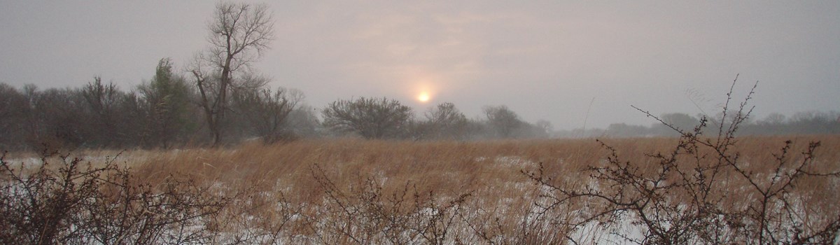 NPS photo | |
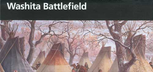
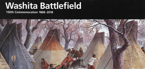
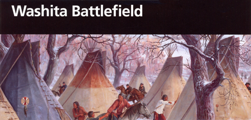
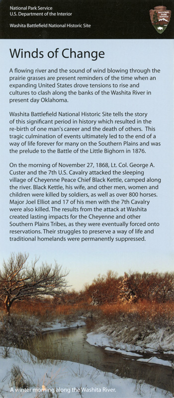
The attack came unexpectedly at morning's first light when the village was most vulnerable. It began with a rifle shot, a bugle sounding "Charge!" and a band playing the opening strains of "Garry Owen." In a moment all was tumult as the charging troopers of Lt. Col. George Armstrong Custer's 7th U.S. Cavalry came splashing across the frigid Washita River into the sleeping Cheyenne camp of Chief Black Kettle. They came in four battalions. Custer led the largest straight into the village. Maj. Joel Elliott and Capts. William Thompson and Edward Myers led the others northeast and southwest in an attempt to surround the encampment. While Custer watched from a knoll to the south, the soldiers drove the Cheyenne from their lodges barefoot and half-clothed and pursued them in all directions. Some of the warriors fought and died in the village; others took up positions behind trees and in ravines and returned fire; many of them escaped. The village's leader, Black Kettle, and his wife Medicine Woman Later, were killed by soldiers while trying to cross the Washita River. When the firing ceased two hours later, approximately 30 to 60 Cheyenne lay dead in the snow and mud.
Following Sheridan's plan to cripple resistance, Custer ordered the slaughter of the village's pony and mule herds, estimated at over 800 animals. He also ordered the burning of the Cheyenne lodges, with all their winter supply of food and clothing. Then, realizing that many more Indians were threatening from the east, Custer feigned an attack toward their downriver camps and quickly retreated to Camp Supply with his captives—53 women and children. The engagement at the Washita might have ended very differently if the larger Indian encampments to the northeast had been closer to Black Kettle's camp. The impact of losing winter supplies, plus the knowledge that cold weather no longer provided protection from attack, forced many bands to accept reservation life.
Prelude to the Attack
Events leading to the attack at Washita River began on November 29, 1864, when troops under the command of Col. J.M. Chivington attacked and destroyed Black Kettle's village on Sand Creek, 40 miles from Fort Lyon, Colorado Territory. At the time, Black Kettle had been pursuing a policy of peace with whites and believed his village to be under U.S. Army protection. Black Kettle survived the attack, but at least 150 Cheyenne and Arapaho men, women, and children were killed and horribly mutilated. It came to be known as the Sand Creek Massacre and resulted in a massive public outcry as well as months of retaliatory raids by Cheyenne, Arapaho, and Lakota warriors.
When the army failed to end the raids, a federal commission was created to make peace with the raiding tribesmen. By the terms of the Treaty of Little Arkansas, signed on October 17, 1865, and the Treaty of Medicine Lodge of October 1867, the Cheyenne, Arapaho, and other tribes agreed to stop their raiding and settle on reservations in Indian Territory (now Oklahoma). There they were to receive permanent homes, agricultural implements, weapons and ammunition for hunting, and annuities of food, blankets, and clothing. The treaties did not bring peace. Many tribal officials refused to sign. Some who did sign had no authority to compel their people to comply with such agreements. And Congress was slow to ratify the treaties and annuities often failed to arrive. Warrior societies, mostly young men violently opposed to reservation life, continued hostilities.
Maj. Gen. Philip H. Sheridan, commanding the Department of the Missouri, adopted a policy that "punishment must follow crime." Frustrated that more traditional campaigning methods failed to defeat the Plains warriors in the field, he prepared a winter campaign when Indian horses would be weak and unfit for all but the most limited service.
To this end, on November 23, 1868, Lt. Col. Custer set out from Camp Supply in Indian Territory with about 700 7th U.S. Cavalry troopers and a dozen Osage scouts. His objective: the Washita River valley where some 6,000 Cheyenne, Arapaho, and Kiowa had laid out winter camps. Traveling through a foot of new snow, the command reached the Washita valley shortly after midnight on November 27 and silently took up positions near an Indian encampment the scouts had discovered at a bend in the river. Coincidentally, the village was that of Black Kettle, who had survived Sand Creek and who had tried so diligently to avoid conflict.
Significant events in Cheyenne and Arapaho history, 1851 to 1869
1851
Treaty of Fort Laramie divides Great Plains into specific tracts of land
for Cheyenne, Arapaho, and other signatories, who promise to live
forever in peace in return for protection against white
depredations.
1859
Discovery of gold in Colorado Territory brings influx of miners,
farmers, and speculators with little regard for Indian rights or ways of
life.
1861
Treaty of Fort Wise moves Cheyenne and Arapaho to a small reservation
south of the Arkansas River to avoid conflict with emigrants and gold
seekers.
1864-65
Cheyenne-Arapaho War begins after younger members of the tribes refuse
to abide by the provisions of the Fort Wise treaty and range far beyond
the reservation, dashing frequently with whites. This creates conditions
that lead to the Sand Creek Massacre. In retaliation, Cheyenne, Arapaho,
and allied Sioux attack Julesburg, Colorado Territory, and raid ranches
and stage stations on South Platte River.
1865
Treaty of Little Arkansas ends Cheyenne-Arapaho War, with U.S.
Government repudiating Sand Creek and promising reparations to the
Cheyenne and Arapaho.
1866
Cheyenne warriors who had not signed the Little Arkansas treaty raid
along Smoky Hill River in Kansas.
1867
Maj. Gen. Philip H.
Sheridan takes command of U.S. forces in the West, proposing to bring
peace to the Plains. Maj. Gen. Winfield S. Hancock begins campaign
against Cheyenne and other tribes rumored to be planning attacks on
Kansas settlements and transportation routes.
Treaty of Medicine Lodge signed in hope of ending hostilities.
1868
Party of Cheyenne, Arapaho, and Sioux attack settlements along the
Solomon and Saline rivers in Kansas.
Southern Plains War begins against the Cheyenne, Arapaho, Sioux, Kiowa, and Comanche. Lt CoL Alfred Sully's summer campaign fails to suppress the tribes.
Sioux and Cheyenne attack and besiege a group of US. Army scouts on Beecher's Island in the Arikaree River, Colorado Territory.
Sheridan's winter campaign begins in October.
Custer's attack along the Washita River, Indian Territory, destroys Black Kettle's village for a second time, killing Black Kettle in the process.
Sheridan's winter campaign continues with attack and destruction of Comanche village at Soldier Spring, Indian Territory, and the surrender of many Cheyenne and Arapaho in 1869.
1869
Battle of Summit Springs, last major encounter between U.S. cavalry and
Plains Indians in Colorado Territory, destroying the cohesiveness of the
Cheyenne Dog Soldiers and ending their effectiveness as a fighting
group.
President Ulysses S. Grant's so-called "Peace Policy" is initiated, emphasizing "conquest by kindness" and viewing Indians as "domestic dependent nations" with which the U.S. must negotiate. On the Southern Plains it lasts until 1874.
Recipe for Disaster
In the decades before the Civil War the U.S. government regarded Indian tribes as sovereign and independent nations and sought ways to remove them from coveted lands as well as protect them against white encroachment. Congress devised a reservation policy that called for concentrating the Indians on small, well-defined tracts of land that legislators believed would be free from white intrusions. Some Plains tribes accepted life on reservations; others did not, continuing to hunt and live on traditional lands outside the reservations. This choice produced little conflict until the 1860s, when the harsh realities of Manifest Destiny saw more and more gold-seekers and land-hungry settlers penetrate the Plains and encroach on tribal hunting grounds. Unable to retreat beyond the reach of whites, many tribes, including the Cheyenne and Arapaho, decided to defend their freedom rather than submit to reservation life.
This led to attacks on wagon trains, stagecoaches, mining camps, and settlements, creating conditions that brought about the Sand Creek Massacre in 1864. Although the government repudiated Sand Creek and promised reparations to the Cheyenne in the Treaty of Little Arkansas (1865), both sides charged violations, and hostilities continued. When the Treaty of Medicine Lodge (1867) failed to end widespread Indian raids, Maj. Gen. Philip H. Sheridan, commanding the Department of the Missouri, prepared a bold and inventive winter campaign designed to catch the Indians when least mobile and most vulnerable. Among those targeted for destruction were the allied Cheyenne, Arapaho, and Kiowa tribes reported to be encamped in the Washita River valley.
Maj. Gen. Philip H. Sheridan
Unlike agents of the Indian Bureau, Sheridan drew no distinction between friendly and hostile Indians. For the sins of the few, he held the whole tribe accountable. "I am of the belief," he wrote at the start of the 1868-69 campaign, "that these Indians require to be soundly whipped, and the ringleaders in the present trouble hung, their ponies killed, and such destruction of their property as will make them very poor." The attack on Black Kettle's village was the first implementation of the Army's strategic decision to launch "total war" against the Indians of the Southern Plains.Lt. Col. George A. Custer
Sheridan believed that, despite a reputation for impulsive behavior, the flamboyant Custer's aggressiveness was the key to successfully implementing the new strategy of attacking the tribes of the Southern Plains in the winter when they were least prepared to resist. Custer's victory at Washita catapulted him into the public's imagination as the nation's preeminent Indian fighter and possibly helped inspire the behavior that led to his death at the Little Bighorn in 1876. He sported a full beard and buckskin outfit during the Washita Campaign.Maj. Joel Elliott
A dedicated, zealous officer, Elliott was Custer's second in command. His command discovered the Indian trail on November 26 that led the 7th U.S. Cavalry to Black Kettle's camp. He entered the village with Custer, then led a small detachment downstream in pursuit of fleeing Indians, where he and his command were cut off and killed. Custer's return to Camp Supply without determining the fate of Elliott and his men angered many fellow officers. The bodies of Elliott and the 17 soldiers who accompanied him were recovered from the battlefield two weeks later on December 11, 1868.Chief Black Kettle
The night before the attack, Black Kettle returned to his village after a 100-mile trip to Fort Cobb, where he and Arapaho Chief Big Mouth unsuccessfully petitioned the post commander for peace and protection. Still confident of their safety, he resisted the entreaties of some of his people, including his wife, Medicine Woman Later, to move their camp closer to the larger Cheyenne, Arapaho, and Kiowa encampments downriver. Black Kettle has been characterized as "a good man with deep wisdom, who devoted his life to trying to lead his people to safety, working against forces too mighty to fight."Edward W. Wynkoop
As Indian agent to the Arapaho and Cheyenne, he worked hard from 1866 to 1868 to prevent hostilities. He vigorously championed the cause of his charges and defended them when accused of depredations, blaming Congress for failing to appropriate funds for liberal food issues and withholding promised annuities. He resigned his post in protest over the Army's new Indian policy, refusing to be party to "the murder of innocent women and children." Wynkoop denounced the attack on Black Kettle's village, comparing Custer to Chivington and Washita to Sand Creek.
American Treaty History
Article six of the U.S. Constitution stipulates that "all Treaties made, or which shall be made, under the Authority of the United States, shall be the supreme law of the land." It makes no distinction between treaties with foreign nations and with Indian tribes. Between 1778 and 1871 the United States negotiated approximately 800 treaties with various Indian tribes, the Senate, however, ratified fewer than 400 (see list below). About one-third of these were peace treaties. Two-thirds were land cessions, of which many were root causes of armed conflicts.
The Indian Appropriations Act of 1871 ended the practice of formal treaty-making but did not invalidate or impair obligations of previous treaties lawfully made and ratified. Few of those treaties, even when first made, were observed for long, sometimes because many Indians who had not signed them did not feel bound to abide by their provisions. More often, Congress failed to appropriate enough money to meet treaty obligations. Broken promises caused peaceful Indians to mistrust U.S. policy and encouraged others in their armed resistance. Such was the case with the Cheyenne and Arapaho (whose treaties are highlighted), creating the climate that led to the attack at Washita.
*In this list of treaties, "etc." means "and other tribes".
1778-1799
Treaty with the Delaware, 1778 • Six Nations, 1784 • Wyandot,
etc.*, 1785 • Cherokee, 1785 • Choctaw, 1786 • Chickasaw,
1786 • Shawnee, 1786 • Wyandot, etc., 1789 • Six Nations,
1789 • Creeks, 1790 • Cherokee, 1791 • Cherokee, 1794
• Six Nations, 1794 • Oneida, etc., 1794 • Wyandot, etc.,
1795 • Seven Nations of Canada, 1796 • Creeks, 1796 •
Mohawk, 1797 • Cherokee, 1798
1800-1809
Treaty with the Chickasaw, 1801 • Choctaw, 1801 • Creeks, 1802
• Seneca, 1802 • Seneca, 1802 • Choctaw, 1802 •
Delawares, etc, 1803 • Eel River, etc., 1803 • Kaskaskia, 1803
• Choctaw, 1803 • Delawares, 1804 • Piankeshaw, 1804
• Cherokee, 1804 • Sauk and Foxes, 1804 • Wyandot, etc.,
1805 • Chickasaw, 1805 • Delawares, etc., 1805 •
Cherokee, 1805 • Cherokee, 1805 • Creeks, 1805 • Choctaw,
1805 • Piankashaw, 1805 • Sioux, 1805 • Cherokee, 1806
• Ottawa, etc., 1807 • Osage, 1808 • Chippewa, etc., 1808
• Delawares, etc., 1809 • Supplementary Treaty with the Miami,
etc., 1809 • Wea, 1809 • Kickapoo, 1809
1810-1819
Treaty with the Wyandot, etc., 1814 • Creeks, 1814 •
Potawatomi, 1815 • Piankashaw, 1815 • Teton, 1815 • Sioux
of the Lakes, 1815 • Sioux of St. Peter's River, 1815 •
Yankton Sioux, 1815 • Makah, 1815 • Kickapoo, 1815 •
Wyandot, etc., 1815 • Osage, 1815 • Sauk, 1815 • Foxes,
1815 • Iowa, 1815 • Kansa, 1815 • Cherokee, 1816 •
Cherokee, 1816 • Sauk, 1816 • Sioux, 1816 • Winnebago,
1816 • Wea and Kickapoo, 1816 • Ottawa, etc, 1816 •
Cherokee, 1816 • Chickasaw, 1816 • Choctaw, 1816 •
Menominee, 1817 • Oto, 1817 • Ponca, 1817 • Cherokee,
1817 • Wyandot, etc., 1817 • Creeks, 1818 • Grand Pawnee,
1818 • Noisy Pawnee, 1818 • Pawnee Republic, 1818 •
Pawnee Marhar, 1818 • Quapaw, 1818 • Wyandot, etc., 1818
• Wyandot, 1818 • Peoria, etc., 1818 • Osage, 1818 •
Potawatomi, 1818 • Wea, 1818 • Delawares, 1818 • Miami,
1818 • Chickasaw, 1818 • Cherokee, 1819 • Kickapoo, 1819
• Kickapoo, 1819 • Chippewa, 1819
1820-1829
Treaty with the Chippewa, 1820 • Ottawa and Chippewa, 1820 •
Kickapoo, 1820 • Wea, 1820 • Kickapoo of the Vermilion, 1820
• Choctaw, 1820 • Creeks, 1821 • Creeks, 1821 •
Ottawa, etc., 1821 • Osage, 1822 • Sauk and Foxes, 1822 •
Florida Tribes of Indians, 1823 • Sauk and Foxes, 1824 • Iowa,
1824 • Quapaw, 1824 • Choctaw, 1825 • Creeks, 1825 •
Osage, 1825 • Kansa, 1825 • Ponca, 1825 • Teton, etc,
Sioux, 1825 • Sioune and Oglala Tribes, 1825 • Cheyenne
Tribe, 1825 • Hunkpapa Band of the Sioux Tribe, 1825 •
Arikara Tribe, 1825 • Belantse-Etoa or Minitaree Tribe, 1825 •
Mandan Tribe, 1825 • Crow Tribe, 1825 • Great and Little
Osage, 1825 • Kansa, 1825 • Sioux, etc., 1825 • Oto and
Missouri Tribe, 1825 • Pawnee Tribe, 1825 • Makah Tribe, 1825
• Shawnee, 1825 • Creeks, 1826 • Chippewa, 1826 •
Potawatomi, 1826 • Miami, 1826 • Chippewa, etc., 1827 •
Potawatomi, 1827 • Creeks, 1827 • Miami, 1828 • Western
Cherokee, 1828 • Winnebago, etc., 1828 • Potawatomi, 1828
• Chippewa, etc, 1829 • Winnebago, 1829 • Delawares, 1829
• Delawares, 1829
1830-1839
Treaty with the Sauk and Foxes, etc., 1830 • Choctaw, 1830 •
Chickasaw, 1830 • Menominee, 1831 • Menominee, 1831 •
Seneca, 1831 • Seneca, etc., 1831 • Shawnee, 1831 •
Ottawa, 1831 • Wyandot, 1832 • Creeks, 1832 • Seminole,
1832 • Winnebago, 1832 • Sauk and Foxes, 1832 •
Appalachicola Band, 1832 • Potawatomi, 1832 • Chickasaw, 1832
• Chickasaw, 1832 • Kickapoo, 1832 • Potawatomi, 1832
• Shawnee, etc., 1832 • Potawatomi, 1832 • Kaskaskia,
etc., 1832 • Menominee, 1832 • Piankashaw and Wea, 1832 •
Seneca and Shawnee, 1832 • Western Cherokee, 1833 • Creeks,
1833 • Ottawa, 1833 • Seminole, 1833 • Quapaw, 1833
• Appalachicola Band, 1833 • Oto and Missouri, 1833 •
Chippewa, etc., 1833 • Pawnee, 1833 • Chickasaw, 1834 •
Miami, 1834 • Potawatomi, 1834 • Potawatomi, 1834 •
Potawatomi, 1834 • Potawatomi, 1834 • Caddo, 1835 •
Comanche, etc., 1835 • Cherokee, 1835 • Potawatomi, 1836
• Ottawa, etc., 1836 • Potawatomi, 1836 • Potawatomi,
1836 • Potawatomi, 1836 • Potawatomi, 1836 • Wyandot 1836
• Chippewa, 1836 • Potawatomi, 1836 • Menominee, 1836
• Sioux, 1836 • Iowa, etc., 1836 • Potawatomi, 1836
• Potawatomi, 1836 • Potawatomi, 1836 • Sauk and Fox
Tribe, 1836 • Sauk and Foxes, 1836 • Sauk and Foxes, 1836
• Oto, etc., 1836 • Sioux, 1836 • Chippewa, 1837 •
Choctaw and Chickasaw, 1837 • Potawatomi, 1837 • Kiowa, etc.,
1837 • Chippewa, 1837 • Sioux, 1837 • Sauk and Foxes,
1837 • Yankton Sioux, 1837 • Sauk and Foxes, 1837 •
Winnebago, 1837 • Iowa, 1837 • Chippewa, 1837 • New York
Indians, 1838 • Chippewa, 1838 • Oneida, 1838 • Iowa,
1838 • Miami, 1838 • Creeks, 1838 • Osage, 1839 •
Chippewa, 1839 • Stockbridge and Munsee, 1839
1840-1849
Treaty with the Miami, 1840 • Wyandot, 1842 • Seneca, 1842
• Chippewa, 1842 • Sauk and Foxes, 1842 • Creeks and
Seminole, 1845 • Kansa Tribe, 1846 • Comanche, Aionai,
Anadarko, Caddo, etc., 1846 • Potawatomi Nation, 1846 •
Cherokee, 1846 • Winnebago, 1846 • Chippewa of the Mississippi
and Lake Superior, 1847 • Pillager Band of Chippewa Indians, 1847
• Pawnee-Grand, Loups, Republicans, etc., 1848 • Menominee,
1848 • Stockbridge Tribe, 1848 • Navaho, 1849 • Utah,
1849
1850-1859
Treaty with the Wyandot, 1850 • Sioux-Sisseton and Wahpeton Bands,
1851 • Sioux-Mdewakanton and Wahpakoota Bands, 1851 • Fort
Laramie with Sioux, Cheyenne, Arapaho etc., 1851 • Chickasaw,
1852 • Apache, 1852 • Comanche, Kiowa, and Plains Apache, 1853
• Rogue River, 1853 • Umpqua-Cow Creek Band, 1853 • Oto
and Missouri, 1854 • Omaha, 1854 • Delawares, 1854 •
Shawnee, 1854 • Menominee, 1854 • Iowa, 1854 • Sauk and
Foxes of Missouri, 1854 • Kickapoo, 1854 • Kaskaskia, Peoria,
etc., 1854 • Miami, 1854 • Creeks, 1854 • Chippewa, 1854
• Choctaw and Chickasaw, 1854 • Rogue River, 1854 •
Chasta, etc., 1854 • Umpqua and Kalapuya, 1854 • Confederated
Oto and Missouri, 1854 • Nisqualli, Puyallup, etc., 1854 •
Kalapuya, etc., 1855 • Dwamish, Suquamish, etc, 1855 •
S'klallam, 1855 • Wyandot, 1855 • Makah, 1855 • Chippewa,
1855 • Winnebago, 1855 • Wallawalla, Cayuse, etc., 1855 •
Yakima, 1855 • Nez Perce, 1855 • Choctaw and Chickasaw, 1855
• Tribes of Middle Oregon, 1855 • Quinaielt, etc, 1855 •
Flatheads, etc, 1855 • Ottawa and Chippewa, 1855 • Chippewa of
Sault Ste. Marie, 1855 • Chippewa of Saginaw, etc, 1855 •
Blackfeet, 1855 • Molala, 1855 • Stockbridge and Munsee, 1856
• Menominee, 1856 • Creeks, etc, 1856 • Pawnee, 1857
• Seneca, Tonawanda Band, 1857 • Ponca, 1858 • Yankton
Sioux, 1858 • Sioux, 1858 • Sioux, 1858 • Winnebago, 1859
• Chippewa, etc, 1859 • Sauk and Foxes, 1859 • Kansa,
1859
1860-1869
Treaty with the Delawares, 1860 • Fort Wise with Arapaho and
Cheyenne, 1861 • Sauk and Foxes, etc, 1861 • Delawares,
1861 • Potawatomi, 1861 • Kansa Indians, 1862 • Ottawa of
Blanchard's Fork and Roche de Boeuf, 1862 • Kickapoo, 1862 •
Chippewa of the Mississippi and the Pillager and Lake Winnibigoshish
Bands, 1863 • Nez Perce, 1863 • Eastern Shoshoni, 1863 •
Shoshoni-Northwestern Bands, 1863 • Western Shoshoni, 1863 •
Chippewa—Red Lake and Pembina Bands, 1863 • Utah—Tabeguache Band,
1863 • Shoshoni-Goship, 1863 • Chippewa—Red Lake and Pembina
Bands, 1864 • Chippewa, Mississippi, and Pillager and Lake
Winnibigoshish Bands, 1864 • Klamath, etc, 1864 • Chippewa of
Saginaw, Swan Creek, and Black River, 1864 • Omaha, 1865 •
Winnebago, 1865 • Ponca, 1865 • Snake, 1865 • Osage, 1865
• Sioux—Miniconjou Band, 1865 • Sioux—Lower Brule Band, 1865
• Little Arkansas with Cheyenne and Arapaho, 1865 •
Confederated tribes of Cheyenne, Arapaho, and Apache, 1865 •
Comanche and Kiowa, 1865 • Sioux—Two-Kettle Band, 1865 •
Blackfeet Sioux, 1865 • Sioux—Sans Arc Band, 1865 •
Sioux—Hunkpapa Band, 1865 • Sioux—Yanktonai Band, 1865 •
Sioux—Upper Yanktonai Band, 1865 • Sioux—Oglala Band, 1865 •
Middle Oregon Tribes, 1865 • Seminole, 1866 • Potawatomi, 1866
• Chippewa—Bois Fort Band, 1866 • Choctaw and Chickasaw, 1866
• Creeks, 1866 • Delawares, 1866 • Cherokee, 1866 •
Sauk and Foxes, 1867 • Sioux—Sisseton and Wahpeton Bands, 1867
• Seneca, Mixed Seneca and Shawnee, Quapaw, etc., 1867 •
Potawatomi, 1867 • Chippewa of the Mississippi, 1867 • Kiowa
and Comanche, 1867 • Kiowa, Comanche, and Apache, 1867 •
Medicine Lodge with Cheyenne and Arapaho, 1867 • Ute, 1868
• Cherokee, 1868 • Sioux—Brule, Oglala, Miniconjou, Yanktonai,
Hunkpapa, Blackfeet, Cuthead, Two Kettle, Sans Arcs, and Santee—and
Arapaho, 1868 • Crows, 1868 • Northern Cheyenne and Northern
Arapaho, 1868 • Navaho, 1868 • Eastern Band Shoshoni and
Bannock, 1868 • Nez Perce, 1868
1870-1890
Agreement with the Sisseton and Wahpeton Bands of Sioux Indians, 1872
• Amended Agreement with Certain Sioux Indians, 1873 •
Agreement with the Crows, 1880 • Agreement with the Sioux of
Various Tribes, 1882-83 • Agreement with the Columbia and Colville,
1883
 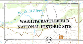 (click for larger maps) |
Note: After 1871, negotiations between the United States and Indian tribes were called "agreements." The U.S. Supreme Court has ruled that, for the most part, agreements are the same as treaties under the law.
Visiting the Park
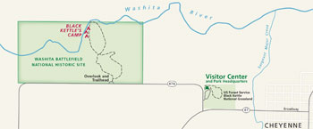
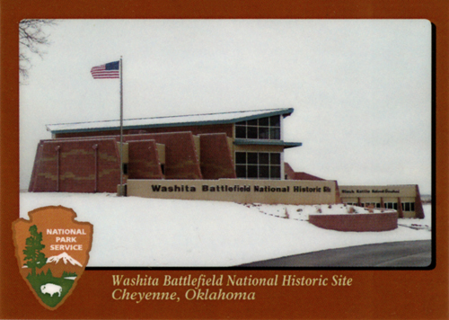
Washita Battlefield National Historic Site is on Okla. 47A, two miles west of Cheyenne, Okla. Cheyenne is located on U.S. 283 about 30 miles north of I-40 and about 20 miles east of the Texas border. Park headquarters and visitor center are in shared facilities with the Black Kettle National Grassland District Office, located one mile west of Cheyenne at the junction of Okla. 47 and 47A. A self-guiding trail and overlook are open daily from sunrise to sunset.
Food, lodging, RV parks, gasoline, and services are available in Cheyenne and nearby communities. Camping, fishing, and hiking trails are available in the Black Kettle National Grassland.
Regulations and Safety
Please stay on the designated trail. The trail is designed for foot
travel only; no pets, bicycles, horses, or motorized vehicles are
allowed. All animals, plants, and artifacts are protected; do not
disturb, damage, or remove them from the park. Please be careful of
ticks and poisonous snakes.
Source: NPS Brochure (2011)
|
Establishment Washita Battlefield National Historic Site — November 12, 1996 |
For More Information Please Visit The  OFFICIAL NPS WEBSITE |
Brochures ◆ Site Bulletins ◆ Trading Cards
Documents
25 for 25 Challenge, Washita Battlefield National Historic Site (2021; for reference purposes only)
25th Anniversary Junior Ranger Booklet, Washita Battlefield National Historic Site (2021; for reference purposes only)
Acoustic Monitoring Report, Washita Battlefield National Historic Site NPS Natural Resource Report NPS/NRSS/NSNS/NRR-2020/2106 (Jacob R. Job, April 2020)
Baseline Inventory of Mammals, Reptiles, and Amphibians at Washita Battlefield National Historic Site, Oklahoma Draft (Mark V. Lomolino and Gregory A. Smith, August 21, 2001)
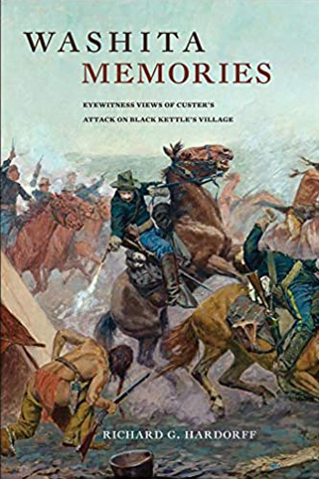
Battle of the Washita (Paul Nesbitt, extract from Chronicles of Oklahoma, Vol. 3 No. 1, April 1925, ©Oklahoma Historical Society)
Battle of the Washita Centennial, 1968 (Francis Thetford, extract from Chronicles of Oklahoma, Vol. 46 No. 4, Winter 1968-69, ©Oklahoma Historical Society)
Cultural Landscape Inventory (Level Two): Washita Battlefield National Historic Site (November 1999)
Cultural Landscape Report: Part Two, Washita Battlefield National Historic Site (John Milner Associates, Inc. and Susan Maxman Architects, September 2003)
Custer on the Washita (Reginald S. Craig, extract from The Denver Westerners Monthly Roundup, Vol. 20 No. 9, September 1964; ©Denver Posse of Westerners, all rights reserved)
Final General Management Plan/Environmental Impact Statement, Washita Battlefield National Historic Site (August 2001)
Foundation Document, Washita Battlefield National Historic Site, Oklahoma (October 2016)
Foundation Document Overview, Washita Battlefield National Historic Site, Oklahoma (January 2016)
Geomorphic Adjustment of the Washita River, Washita Battlefield National Historic Site, Oklahoma NPS Technical Report NPS/NRPC/WRD/NRTR-2007/070 (Richard A. Marston and Todd Halihan, December 2007)
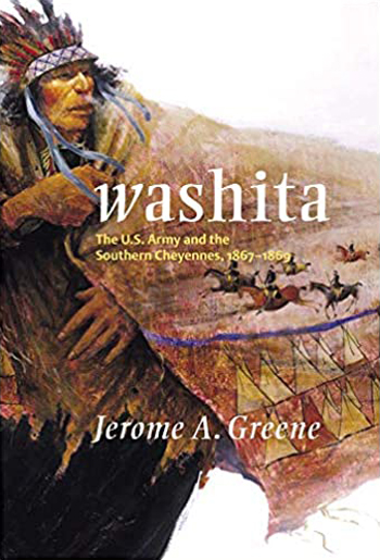
Historic Resource Study: Washita Battlefield National Historic Site, Oklahoma (Jerome A. Greene, September 2001)
History Underfoot: The Search for Physical Evidence of the 1868 Attack on Black Kettle's Village (William B. Lees, Douglas D. Scott and C. Vance Haynes, extract from Chronicles of Oklahoma, Vol. 79 No. 2, Summer 2001, ©Oklahoma Historical Society)
Impacts of Visitor Spending on the Local Economy: Washita Battlefield National Historic Site, 2013 NPS Natural Resource Report NPS/NRSS/EQD/NRR-2014/800 (Philip S. Cook, April 2014)
In Memoriam: Brevet Major Louis McLane Hamilton (extract from Chronicles of Oklahoma, Vol. 46 No. 4, Winter 1968-69, ©Oklahoma Historical Society)
Junior Ranger, Washita Battlefield National Historic Site (Date Unknown; for reference purposes only)
Junior Wildland Firefighter Activity Book, Washita Battlefield National Historic Site (Date Unknown; for reference purposes only)
National Register of Historic Places Nomination Form
Washita Battlefield (Joseph Scott Mendinghall, June 13, 1976)
Natural Resource Condition Assessment, Washita Battlefield National Historic Site NPS Natural Resource Report NPS/SOPN/NRR-2014/748 (Kimberly Struthers, Robert E. Bennetts, Nina Chambers, Tomye Folts-Zettner, Heidi Sosinski and Patricia Valentine-Darby, January 2014)
Oklahoma Outdoor Ranger (Date Unknown; for reference purposes only)
Park Newspaper (The Oklahoma Update): June 2009 • January 2010 • Summer 2010 • Winter 2010 • Fall 2011 • Winter 2011 • Spring 2012 • Spring 2013 • Fall 2013 • Summer 2014
Soil Survey of Washita Battlefield National Historic Site, Oklahoma (2015)
Some Reminiscences of the Battle of the Washita (Theodore A. Ediger and Vinnie Hoffman, extract from Chronicles of Oklahoma, Vol. XXXIII No. 2, Summer 1955, ©Oklahoma Historical Society)
Special Report on Washita Battlefield, Oklahoma (William E. Brown, July 1964)
The Battle of the Washita (Lewis N. Hornbeck, extract from Sturm's Oklahoma Magazine, Vol. 5 No. 5, January 1908)
The Battle of the Washita (Tahan, extract from Chronicles of Oklahoma, Vol. 8 No. 3, September 1930, ©Oklahoma Historical Society)
The Battle of the Washita, Revisited (Howard F. VanZandt, extract from Chronicles of Oklahoma, Vol. 62 No. 1, Spring 1984, ©Oklahoma Historical Society)
The Nineteenth Kansas Calvary in the Washita Campaign (Horace L. Moore, extract from Chronicles of Oklahoma, Vol. 2 No. 4, December 1924, ©Oklahoma Historical Society)
The Washita Trail: The Seventh U.S, Cavalry's Route of March to and from the Battle of the Washita (Bob Rea, extract from Chronicles of Oklahoma, Vol. 76 No. 3, Fall 1998, ©Oklahoma Historical Society)
Vegetation Analysis, Washita Battlefield National Historic Site (Priscilla Scotts and Robert DuBey, August 1998)
Vegetation Classification and Mapping Project Report, Washita Battlefield National Historic Site NPS Natural Resource Technical Report NPS/SOPN/NRTR-2007/075 (Dan Cogan, May 2007)
Washita (Mary Jane Warde, 2005)
Water Resources Scoping Report, Washita Battlefield National Historic Site, Oklahoma NPS Natural Resource Technical Report NPS/NRWRS/NRTR-99/235 (John Reber, Mark Flora and Jim Harte, May 1999)
Washita Battlefield 25th Anniversary
Part One (Duration: 15;24, November 13, 2021)
Part Two (Duration: 4;48, November 13, 2021)
Part Three (Duration: 24;16, November 13, 2021)
Part Four (Duration: 16;30, November 13, 2021)
Part Five (Duration: 26;33, November 13, 2021)
Washita Battlefield National Historic Site
Books
waba/index.htm
Last Updated: 26-Dec-2023