
|
Washington Department of Natural Resources Geology and Earth Resources Division Bulletin No. 66 Geology of the Washington Coast between Point Grenville and the Hoh River Weldon W. Rau |
PART II
Geologic Observations and Interpretations Along Segments of the Coast
CAPE ELIZABETH TO DUCK CREEK
HIGH CLIFFS OF THE QUINAULT FORMATION
Northward from Cape Elizabeth for about 1-1/4 miles the Quinault Formation continues to outcrop in very high cliffs (fig. 39). Younger sand and gravel deposits above are relatively thin, in places only two or three feet thick.
Immediately north of the main promontory of Cape Elizabeth another sea arch has formed in a small sandstone and conglomerate point. Although today it is possible to walk upright through this arch, in 1900 only a small hole existed, barely large enough for crawling space. The nearby sea stack may well have been attached at one time to this point. Perhaps an arch existed here sometime in the past, also.
Northward, the sandstone and conglomerate beds of the Quinault Formation dip gently eastward into the cliffs. Sandstone becomes prevalent northward (down section) and some siltstone beds begin to appear. The several small headlands occurring in this area are relatively thin beds of resistant conglomerate and represent the lowest conglomerate beds in this part of the Quinault Formation.
About 1 mile north of Cape Elizabeth the Quinault Formation is largely siltstone and fine-grained sandstone. Major landslides have developed in these relatively incompetent rocks for a distance northward of nearly a quarter of a mile.
JUMBLED DEPOSITS OF HOH ROCKS
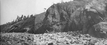
Landslide outcrops of the Quinault Formation are terminated to the north at a fault contact between this formation and jumbled, darker colored, and older Hoh rocks (fig. 53). From this point northward for over a quarter of a mile, a completely chaotic mixture of broken and squeezed siltstone, together with blocks of more resistant rocks, form the slumped cliff outcrops (fig. 42). Bedded sandstone and siltstone, massive sandstone, and altered igneous rocks are common among the resistant blocks. Much slumping has occurred along the cliffs of this area. In places the materials have moved down the cliffs as mudflows. The many large boulders resting on the beach and the nearby offshore reefs are blocks that have resisted erosion, while the cliffs have receded eastward.
|
| CONTORTED DEPOSITS OF HOH ROCKS about three-quarters of a mile south of Duck Creek. Note the contact between Hoh rocks and the more resistant and upturned sandstone beds of the Quinault Formation on the right. Disarranged Hoh rocks are believed to have been squeezed upward deforming the overlying Quinault Formation. (Fig. 42) |
This outcrop area is of particular interest to geologists because it is believed to expose a geologic structure similar to many others that have been delineated recently by geophysical exploration offshore in the subsurface of the Continental Shelf (fig. 12). These structures are referred to as "piercement structures". The jumbled materials visible in this quarter of a mile of outcrop are believed to have been squeezed upward into the younger Quinault Formation, here exposed adjacent to Hoh rocks both to the north and south. Erosion has removed any of the younger formation that might have been domed over the "plug" of jumbled materials (see Part I, The Hoh rock assemblage, Piercement structures).
|
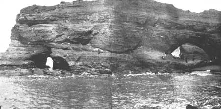
| LOOKING NORTHWARD AT CAPE ELIZABETH, 1970. Since 1902, the large arch on the right in figure 44 has become a wide gap. Note the large boulder on the floor of the present-day gap, a remnant of the conglomerate roof of the old arch. (Fig. 43) |
|
| A VIEW TAKEN ABOUT 1902 looking northward at sandstone and conglomerate strata of Cape Elizabeth. Compare with present-day view shown in figure 43. Photo from Washington Geological Survey Bulletin no. 13. (Fig. 44) |
UPWARPED QUINAULT SILTSTONE, SOUTH OF DUCK CREEK
Siltstone beds of the Quinault Formation are continuously exposed in the cliffs northward from the jumbled Hoh rocks nearly to the mouth of Duck Creek, a distance of about three-quarters of a mile (fig. 29). The cliffs in the first few hundred yards northward of the Hoh deposits are badly slumped just as they are immediately south of the Hoh rocks. Northward to Duck Creek the Quinault Formation contains numerous fossils. Foraminifera are particularly abundant. In addition, many small sedimentary structures can be seen in individual beds which indicate much disruption or local churning of the sediments prior to consolidation (fig. 20). Most of this was likely accomplished by burrowing marine organisms. In traversing past these outcrops from south to north, note that the direction in which the strata are tilted changes from a south-southeast direction to an eastward direction; then, finally in the area immediately south of Duck Creek, the beds dip in a northerly direction. Structurally, in this distance of three-quarters of a mile, the traverse crosses an eastward plunging "anticline" (an upward arched fold) in the Quinault Formation, the top of which has been beveled or removed by erosion.
| <<< Previous | <<< Contents >>> | Next >>> |
state/wa/1973-66/sec2-4.htm
Last Updated: 28-Mar-2006